**Click any picture to see enlarged.**

Day 5 General Route

The image above depicts the section hiked for the day. The YELLOW path is supposed to be the trail based on sources and maps I used to plan my trip, while the RED path is the route my GPS app (GAIA) tracked on my phone. They are fairly close for the most part. More apparent deviations indicate that I either missed the appropriate trail marker, the real trail has alternative routing, or the true trail is not the route highlighted in yellow.
September 22, 2019
Another 7AM morning. The picture below is the morning view from my room. I packed up my gear and took care of the usual morning routine before heading down to the dining area for coffee, breakfast and turn in my room key. Breakfast (zajtrk) was bread with a selection of nutella, honey, jam and butter. After settling up my bill, I went outside to get one last view. I also filled up my water before heading out on the trail.

Dom na Smrekovcu – Komen (~2.92mile/4.69km)
Segment 1: Route Segment 1: Elevation Profile


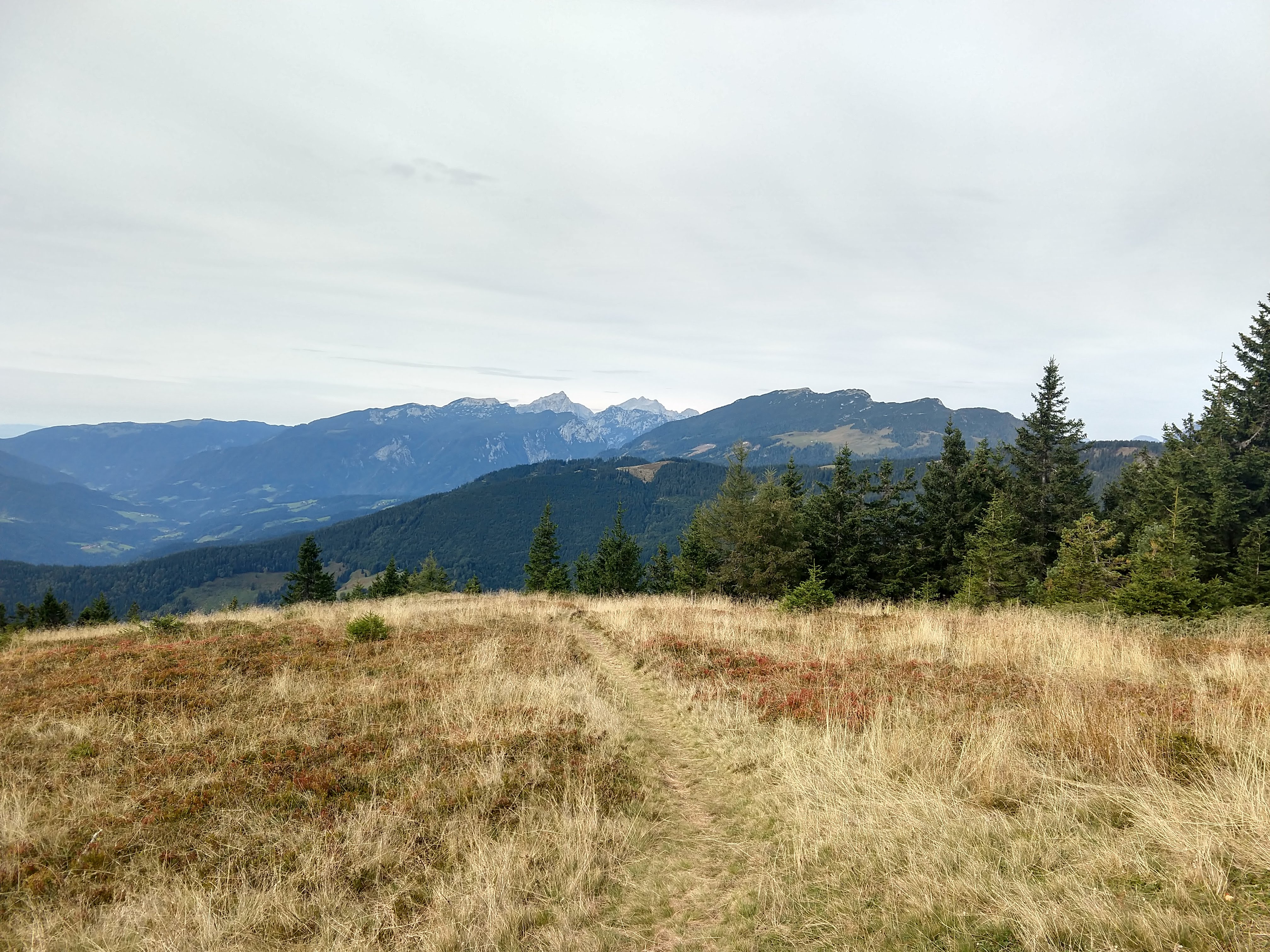
I departed Dom na Smrekovcu around 0907AM. At first the trail takes you through woods up to just below the ridge line of the Smrekovec-Komen ridge (greben). Then through several semi-open meadows with views to the south as you head west. You can also see the tall and exposed mountains of the Kamnik-Savinja Alps (Kamniško-Savinjske Alpe). Over the 2.92miles you gain about 1200 ft in elevation to get to Komen. Komen stands at around 5447ft. On top of Komen you gain a great unobstructed 360-degree view of the region. The photos below were sequentially taken along the route.
Southeast view – Golte Ridge/Plateau Komen within reach Western view heading toward Komen Southwestern view heading toward Komen South view heading toward Komen Komen: Northeast View – Urlšja Gora (center) Komen: North View Komen: Northwest View – Peca (center) Komen: West view -Olševa (center) Komen: West view – Raduha (center, far-middle-ground), Travnik (right-center, middle-ground) Komen: Southwest View Komen: South View Komen: Southeast view – Golte Ridge/Plateau (center), Boskovec (left-center high-point) Komen: East view


Komen – Koča na Travniku (~2.52mile/4.05km)
Segment 2: Route Segment 2: Elevation Profile


Upon departing Komen, I headed by the little shelter before continuing on toward Koča na Travniku. This was an easy going segment with more walking through open meadows along the ridge, with a scattering of wooded areas. The elevation chart looks a little more dramatic with the smaller scale. I arrived at the mountain hut around 1150AM, roughly 1hr 15min from Komen. During this segment the color of the meadow gave an early fall impression.
Looking back toward Komen


Koča na Travniku
When I got the mountain hut there was a family hanging around the outdoor table area. The mountain hut hosts were inside working on lunches for the group. Since it was still a little early for lunch for me I decided to hold out til my next destination. The pictures below will give you a sense of the inside. There were accommodations for a few folks if you wanted to stay, but definitely smaller than the lodge back at Smrekovcu.


Koča na Travniku – Koča na Loki pod Raduho (~4.1mile/6.59km)
Segment 3: Route Segment 3: Elevation Profile


I departed the mountain hut a little after noon. This next stretch would take a little longer, but roughly 2 hrs til the next mountain hut and lunch. Through this next portion I spent more time in the woods until coming out through someone’s property with cattle. Once I crossed the road I made my way back up in elevation (that I had just lost). Eventually you arrive at a dirt road and follow along that until you reach Koča na Loki.


Koča na Loki pod Raduho
I arrived at Koča na Loki around 1410, a few minutes shy of 2hrs. This would be my mid-day break point where I would take the pack off, let the boots and socks air out while I had some lunch and performed some stretching. For the most part the sun was out, though it looked like some denser clouds were further south. Lunch today was ričet with dried klobasa and of course ample bread, as well as a Laško. There were several groups at the mountain hut relaxing on the benches in the outside front area.
Ričet and Laško, 8.5EUR Koča na Loki pod Raduho


Koča na Loki pod Raduho – Koča v Grohotu pod Raduho (~3.45mile/5.55km)
Segment 4.1: Route Segment 4.1: Elevation Profile


After about an hour, I put my gear back on and headed out around 1510. By this time the clouds to the south and west were looking darker with a possibility of rain in the near future heading my way. After a good hearty meal, I was a little slow going on the trail. Pretty much from the mountain hut to the top of Raduha is an all uphill journey.
As I progressed up the trail, the trail quickly became more rocky, with lots of high steps. Additionally, part way up it began to sprinkle. This was my initial exposure to how slick the rocks were when just slightly wet, which made me a little more cautious to prevent slipping and potentially having another shoulder dislocation.
When I got to the trail split to go to Velika Raduha (summit), I decided to just head to the mountain hut. The time was now 1613. The out and back to the summit would have taken roughly an hour and with the rain coming down a little more, I didn’t really want to risk having a more difficult descent since I still had no clue what the back side descent was going to look like either.
Below is the route and elevation profile of where I took the trail directly to Koča v Grohotu.
Segment 4.2: Route Segment 4.2: Elevation Profile


The north side descent was initially steep looking standing at the top looking down toward my evening mountain hut. On the descent, the gravel on the trail was loose so I took an extra slow time making my way down to prevent slipping or tumbling down. Besides I could see the mountain hut so no matter how bad it got, I was super close.
In the pictures below you can get an idea of the rock and the way down to the mountain hut. The views from the top were pretty decent considering the lower clouds and rain haze.
As I made my way down, I could hear voices that sounded like they were above me so I assessed the wall to find a couple climbers working their way up the rock face. Once I got passed the gravel, rocky trail, the path leveled off nicely into a grassy trail that took you by a lodge of some sort that looked like an medical post. As you follow along the road you eventually get to Koča v Grohotu.
I arrived around 1745. The place was open and there was only one other hiker in the lodge. I had seen him at the previous lodge the night before so began chatting with him while I checked in and laid my gear out to dry.
Seeing the rain in the distance North side of Raduha Koča v Grohotu Raduha


Side note:
You may notice that I have used a couple different variations of Koča v Grohotu. Depending on the map or website you use it appears differently. v (vuh) = in; na (nah) = on.
- Koča v Grohatu pod Raduho
- Koča na Grohotu pod Raduho
You will also see “Planinska koča na Grohotu” on Google Maps, which is just “Mountain hut on Grohot”. These variations are somewhat common.
Daily Hiking Stats
- Total Distance: ~12.99miles / 20.90KM
- Estimated Elevation Gain/Loss: +5233ft / -4934ft
- Total time hiked: 8 hours 45 minutes (1hr mid-day break)
Relaxing Evening at Koča v Grohotu pod Raduho
After getting situated with my wet gear and changed into some dry clothes, I order some food and beer. The rest of the evening was spent chatting with the a Slovenian hiker who was also hiking the Slovenian Mountain Trail. The guy had started the same day as me in Maribor and we almost crossed paths several times over the previous few days, but I definitely remembered seeing him at the last mountain hut. He told me about his hiking trip and time in the US to hike the Continental Divide Trail. It was certainly interesting to hear about his perspective and to hear about the experiences between the two long distance trails. After swapping stories back and forth over dinner, we began planning for the following day’s hike.
As we compared notes and planned for the next day, weather was looking less desirable to continue along the original path through Robanov Kot to one of the mountain huts near Ojstrica. Within the past few weeks there are been a couple of deaths due to rain and resulting conditions, so we looked to see what alternatives would be viable given the weather may not improve over the next day or two. The route up to Ojstrica would have exposure and likely via ferrata portions. The rock, limestone, also becomes quite slick when wet, which increases the risks along an already riskier portion.
Luckily we found an alternative to somewhat bypass and still link up with the next mountain hut along our path. First we would redirect to Solčava then head west along the road to Logarska Dolina (valley) then head up to Fischaufov dom na Okrešlju. We decided we would head out on this next section together. After finishing desert I headed up to get ready for bed and proceed to sleep to make way the next day.
Slovenian-English Translation
- Zajtrk = Breakfast
- Ričet = Barley Stew
Current Trip Costs
The total daily cost was 39 EURO.
- Transportation: 0 EURO
- Food: 25 EURO
- Lodging: 14 EURO
- Running Total Cost: 866.85 EURO
Previous Slovenia Posts
- Trip Planning: Slovenian Mountain Trail, part 1
- Slovenia Trip: Pre-Hike Days
- Slovenian Mountain Trail: Day 1
- Slovenian Mountain Trail: Day 2
- Slovenian Mountain Trail: Day 3
- Slovenian Mountain Trail: Day 4
- Slovenian Mountain Trail: Day 5
- Slovenian Mountain Trail: Day 6
- Slovenian Mountain Trail: Day 7
Useful Links
- Dom na Smrekovecu
- Koča na Loki pod Raduho
- https://www.facebook.com/kocanalokipodraduho/
- https://www.pzs.si/koce.php?pid=94
- http://www.hribi.net/gora/koca_na_loki_pod_raduho/3/409
- Koča v Grohatu/Koča na Grohatu
- https://www.pzs.si/koce.php?pid=95
- http://www.hribi.net/gora/koca_na_grohatu/3/615
- http://grohot.eu/grohot/
- Koroška Tourist info
- Very Useful offline map app of Slovenia (android link): https://play.google.com/store/apps/details?id=org.mapapps.mapyourtown.slovenia&hl=en_USGAIA App (android link): https://play.google.com/store/apps/details?id=com.trailbehind.android.gaiagps.pro
- Google Fi Phone Service: referral link
- Resources for learning Slovene
- https://www.slonline.si/ (great resource, free)
- Colloquial Slovene Book: Amazon Referral Link
- Colloquial Slovene Book-Audio clips: https://www.routledgetextbooks.com/textbooks/colloquial/language/slovene.php
- https://www.thinkslovenia.com/info-activities/slovenian-language-learning

