**Click any picture to see enlarged.**

The image above depicts the section hiked for the day. The YELLOW path is supposed to be the trail based on sources and maps I used to plan my trip, while the RED path is the route my GPS app (GAIA) tracked on my phone. They are fairly close for the most part. More apparent deviations indicate that I either missed the appropriate trail marker or the real trail has alternative routing.
September 18, 2019
The alarm went off at 7AM, which despite being shorter than I would like, made me better rested than the previous night and ready to get this journey started. I took some time waking up to continue some last minute shuffling of some gear and getting ready. I headed down to the dining area to have a solid breakfast and some coffee. This place was worth every bit of the 32.5€ for private room and breakfast and would certainly stay here again.
After changing over and grabbing my gear, I went to check-out and left the Hostel by 10AM. To get to the starting point of the Slovenian Mountain Trail, I headed east toward Ljubljanska ulica (street) and walked on the sidewalk south until the road T’s into Streliška Cesta (road). Hang a right (west) along the Cesta for about 0.25 miles (0.41KM) until you get to Pot na Okope. The map below depicts the route i walked in blue.

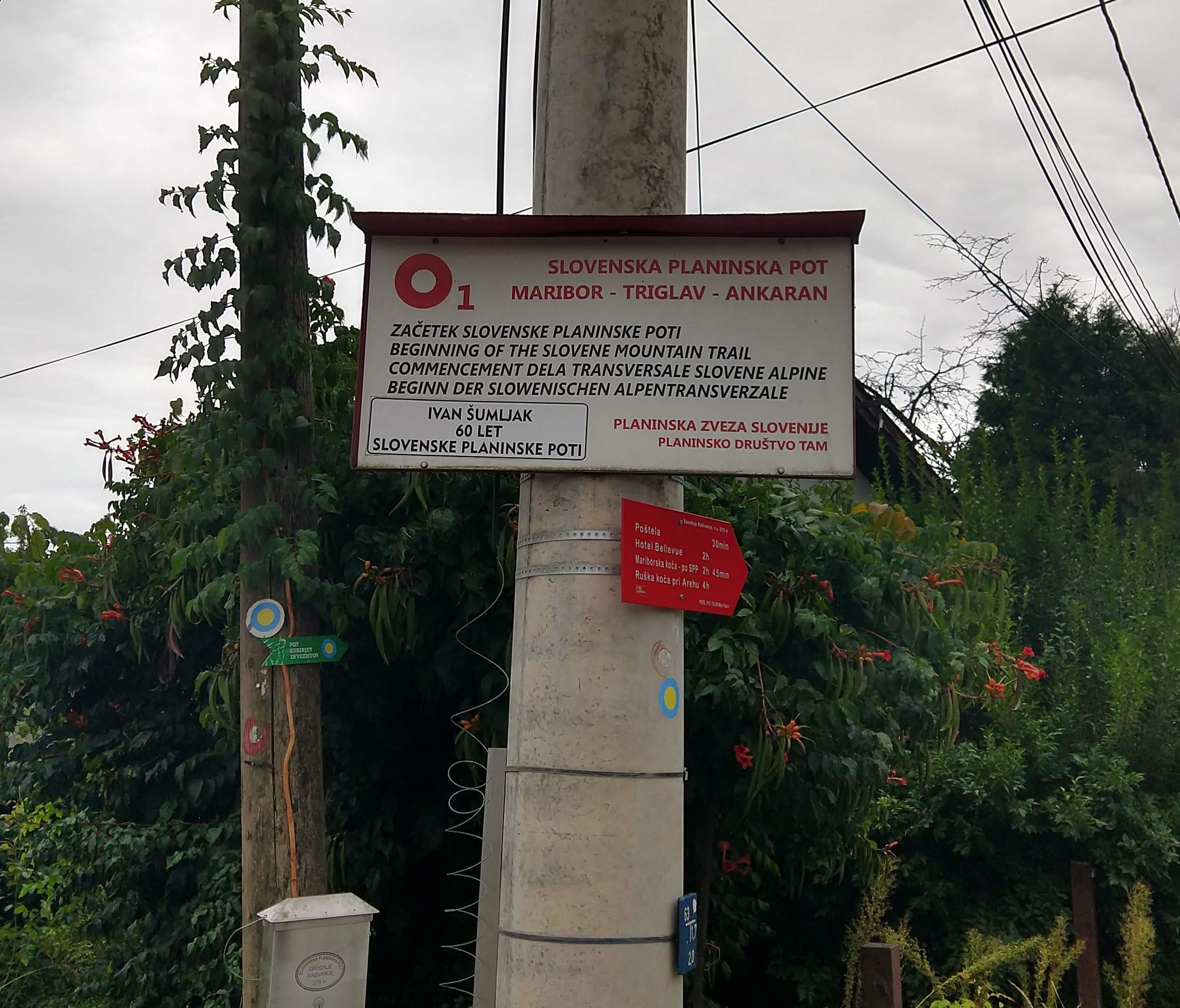
Where I’m headed Pot na Okope Start of the Trail sign More Trail Signage


The White dot with Red circle around it is the Knafelc blazes. The Knafelc blaze with subscript of 1 is the marker you will follow the entire way if you are hiking the Slovenian Mountain Trail (SMT), or Slovenska Planinska Pot in Slovene. The 1 signifies the trail number and primary route of the transversal. The SMT was also the first transversal hiking trail in Europe. It was also originally named the Slovenian Mountain Tranversal from 1953-1991.
The Knafelc blaze is generally very easy to spot and generally in close proximity to the previous and next blaze, which are typically on trees or rocks, but not always. Also generally you can stand at one blaze point and see the next one, but this is not always the case as I would find out shortly after starting and later in the day. Based on the signage with estimated times to the next location, it should take about 2hr 45 minutes to finish section 1 of the day.
Maribor Starting Point to Mariborska Koča (~5.22mile/8.39km)
Day1 Section 1 General Elevation Profile


I arrived at the start of the Slovenian Mountain Trail around 10:35AM. It took about 35 minutes to get here from Hostel Pekarna. During this first section I noticed several older people with bags and baskets on trails presumably mushroom hunting. I would see this type of stuff throughout various areas along my hike but being my first expression it seemed odd because I didn’t exactly know what they were doing in the woods.
The following pictures should give you an idea of the variety of trail, the surrounding environment and what the signage of the trail is like. During this first portion I definitely missed a trail marking and spent some time figuring out where the trail was and if I was on the appropriate trail I was supposed to be on. Eventually I found a trail that took me into my primary trail or after walking a little further I saw my next Knafelc. As you can see from the elevation profile above, its pretty much all uphill from the start.
View down toward Maribor


After about 2hrs 11min of being on the trail I stopped at the eastern most ski lift area that overlooked the city of Maribor, as you can see in a picture above. By this time it was 1214PM so decided to take a short break to take some pictures. Below are also my final pack configuration that remained for the rest of the trip.


About 10 minutes of break time, I saddled up and continued on. At 1247PM, I arrived at Hotel Bellevue, which is the main ski lift/lodge area above Maribor from what I gathered. There are restaurants available but I decided to snack on my trail food instead. By this point my heart rate monitor was indicating I had burned 1902 calories. It was a good thing I consumed a lot of calories for breakfast, but if I was to sustain for the day it would be important to take in calories periodically. The photos below capture the views along the way to Mariborska Koča.
Shrine Hotel Bellevue Hotel Bellevue Hotel Bellevue Ski lift Ski lift and view Area map with lots of information All the trails in the area Hotel Bellevue Direction Arrows


The religious shrine above is very common throughout the entire trail that I walk. Each shrine differs in some form or fashion as you will see in the forthcoming daily posts. There are also lots of shrine, memorials and monuments dedicated to the Slovene Partisans as well as other notable Slovene figures.
Church of St. Bolfenka, Oak Shrine Various cabins along the way Various cabins along the way Spomni Se Žrtev za Svobodo, “Remember the Victim for freedom” Memorial Turn off to Mariborska Koča Monument to the Father of the Slovenian Mountain Trail Mariborska Koča Mariborska Koča Mariborska Koča Father of the Slovenian Mountain Trail Various Merchandis inside the


Historical Side note:
According to the Alpine Association of Slovenia,
“Hiking across the Slovenian mountains started in 1953 with the path which was not only revealing its beautiful features but also taking the mountain hikers from the Pannonian plains across plateaus and hills all the way to the Slovenian coast. Here, everyone can find something for their own taste. Professor Ivan Šumljak (1899-1984), a publicist, lecturer and head of the Maribor trailblazing unit, sent a written proposal for the mountain trail to the Slovenian Alpine Association as early as 1950. While performing trailblazing, it occured to him: »Why not connect all these spots by means of one single blazed trail which would extend further on, across the entire Slovenian territory …!« This is how Slovenia became the first European country to have a unique transversal trail. “
During this portion you are also walking on roads and through areas with mountain cabins. This would not be uncommon for a lot of the hiking sections. A lot of times, the trail is on a long sections of forest road or even paved maintained road. This is quite different from what most in the US would consider for hiking trails. When the trail is not on the road it does vary in condition, composition, as well as width.
Mariborska Koča to Ruška koča (~2.78mile/4.47km)
Day1 Section 2 General Elevation Profile


The mountain hut was open and would’ve been a good place to get some food in hindsight, but I was ready to continue on without much delay as I knew I was not even half way done for the day. I departed Mariborska Koča at 1356. According to my estimates I should get to Dom na Pesku in a little over 7hrs(or ~9PM).
My next destination was Ruška Koča pri Arehu, which the sign indicated would take about an hour or so. The photo gallery below depicts the views and scenery throughout this section. I arrived at the Ruška Koča around 1540. During this section, the visibility drastically changed and become quite foggy but the slight drop in temperature felt good. During this portion I also passed by several mass grave sites and memorials at the burial sites.
Mass Grave Site Mass Grave Site Info Mass Grave Site Mass Grave Site Mass Grave Site Public Water near Ruška koča


Ruška koča to Pri Bajgotu (Šumik) (~3.90mile/6.27km)
Day1 Section 3 General Elevation Profile


Around 1530 I had passed Ruška Koča without much of a stop. A little further up the trail I somehow deviated onto what I thought was the trail, but I was unable to track any trail blazes so I had to navigate on the trail I was on and head towards a road/trail that looked promising. Eventually I came to a road and noticed a sign that directed me toward Šumik. After walking down the forest road (with correct trail blazes) for a bit, I reached Pri Bajgotu (Šumik). I had already been hiking for 7 hours 9 minutes by this point and still had about 2 hours 30 minutes to get to Koča na Pesku. By this point I had also burned almost 5000 cal and was feeling pretty hungry for a solid meal that wasn’t a Cliff bar at my final destination.


Pri Bajgotu (Šumik) to Koča na Pesku (~7.98mile/12.79km)
Day1 Section 4 General Elevation Profile (GPS)


Šumik appeared to be a picnic area so I did not spend anytime lingering around and was more focused on getting to Koča na Pesku preferably before it got too late. During my post trip look back in writing on this section, I missed the nearby waterfall and the Koča Šumik, which was up the road a little bit from where I turned off from.
The following pictures are from the next section. During this portion the visibility had certainly cleared up so I could see a little more of the surrounding landscape. As I got closer to Koča na Klopnem vrhu, I noticed a trail split for Pesek (Dom na Pesku). After assessing the time and my exhaustion I decide to skip the additional 1-2km an just get to my final destination.
Trail signage Views from the trail Cabin just off the trail Follow the Knafelc Trail signage Pohorje Partisan Memorial Short cut trail to Pesek Trail signage to Klopni Vrh Trail signage


Around 1900 it was noticeably darker out but not quite dark to need a headlamp out. Within 25 minutes or so I would need to dawn my headlamp to prevent stumbling around on the exposed root and semi-rocky trail. I still had about 30 minutes left until reaching my end destination for the night.
Due to the darkness I got disoriented quite a bit, even with orienting utilizing my GPS coordinates and maps to track where the trail was supposed to be. Finding the trail was increasingly difficult even with my headlamp on. I did a lot of going down what appeared to be a trail then noticing how far I was off from the trail on my GPS then backtracked some to re-link up with the proper trail. Eventually I noticed a light in the distance through the semi-dense forest. As I got closer, it was in fact where I needed to be so all was good and I was happy to be almost done for the day.
45 Minutes more?!? Last sign of the night. Im close!


I arrived at the mountain hut at 2022. Unfortunately for me the hut was closed. The lights were out inside and the front door was locked. Oh great! The sign indicated they close at 8PM….22 minutes late at least by my watch and who knows if they didn’t close up earlier than that.
By this time I was quite parched after having run out of water in the last 30-45 minutes so I scoped out around the facility and found the drinkable water spout area and filled up my water reservoir. At least I had access to water, otherwise this could have been a little more of an issue. I did make several attempts to call the number on the listing but could only hear the phone ring just on the other side of the wall of the entrance. It would seem that my odds of getting inside would be extinguished, though I held hopes that someone would hear my knocking and phone calls to inspect what the noise was from, to no effect.
Daily Hiking Stats
- Total Distance: ~21.67miles / 34.87KM
- Estimated Elevation Gain/Loss: +6390ft / -2736ft
- Total time hiked: 9 hours 55 minutes
- Total Calories burned: 7088 Cal
Night Time at Dom na Pesku
Upon realizing the cold reality of the situation, I took solace in the fact I had access to water outside the facility and there were benches and tables covered by patio umbrellas that I could use for some shelter from the elements and sleep. Although not desirable the un-comfortability of the situation was livable. I would make a bed on the a bench with my gear to increase the amount of scarce insulation and attempt to make the best of the situation. When you dont show up on time or communicate ahead of time, there is no one to blame but yourself. I had endured many uncomfortable nights in the past so what is one more?
I quickly put on all my warming layers as the temperature and not moving was starting to set in on me. I changed out of my sweaty clothes in lieu of dry ones, then bundled everything else I had on me for added warmth from my head to my feet. While I took in some more nutrition to give me calories to keep the engine warm through the night and rehydrate, I began to walk around and did some light stretches. Eventually I would do some light excercises to get the blood flowing for warmth to my core and extremities. During this time I was able to get on the WiFi and search to see what could possibly be in the area to serve as an alternative. I also made sure to keep my parents posted on where I was and the situation.
There was a place (Rogla) about an hour down the road by foot but after lots of internal debate, I opted to not to walk anymore for the night. It would be a shame to walk another hour just to find out the next place was closed as well. It had already been a long day and I was quite exhausted and definitely in a deficit of calories. Between roughly 1000 calories for breakfast, 200-250cal per Cliff and protein bar, I probably had only taken in 2000 calories for the day. According to my heart rate monitor, I burned 7088. Not a great way to start a 3 week hiking trip.
For sleeping, I wrapped myself as best I could in the space blanket I had, on top of my pack and duffel bag to gain some, however little of insulation. The bench width was probably 1foot wide. Needless to say was a very long, super cold, and very uncomfortable night, but I survived. I probably got a few hours of sleep. In between bouts of trying to sleep I would walk around and do jumping jacks to warm up some while reading the menu out front. Everything looked good. I kept thinking about a warm mean and lots of coffee as soon as they opened up at 8AM. Throughout the night I tracked the temperature to be mostly between 2-7 degrees Celsius (35.6-44 degrees Fahrenheit)
The photos below are the views from the next morning to give an idea of my approach to Pesek the night before along with where I ended up sleeping.


Lessons Learned
- Call ahead to make sure the place you plan to stay at is open, what time they close (especially in the off-peak season).
- If I were to hike this portion again, I would budget two days and just stay the night at Mariborska Koča even though it would have been a shorter first day, it would have helped with pacing and exhaustion for the rest of the trip. In later days, I felt the effects of having an initial long day, followed by another equally long day. The gradual increase in mileage per day would have benefited the Phase 1 section of my trip.
- It was a good thing I had brought food to sustain me along the trail. Nutrition is quite important when burning the volume of calories.
Slovenian-English Translation
- Dobro jutro (doh-bro you-tro) = Good morning
- acceptable for early morning until 8-9AM
- Dober dan (doh-ber dahn) = Good Day
- Acceptable throughout the day but traditionally 8/9AM-6PM
- This is the most common expression and you will hear it a lot
- Dober večer (doh-ber ve-ch-er) = Good Evening
- generally after 6PM
- Lahko noč (lah-koh no-ch) = Good night
- Hvala (Hua-lah) = Thanks
- Prosim (pro-seem) = Please
- Oprostite (oh-pro-sti-teh) = Excuse me
- Koča (ko-cha) = mountain hut, cabin
- Dom (dohm)= larger mountain hut, typically larger in capacity and services than a koča.
Current Trip Costs
This was a particularly unusual day where I spent no money, which is because I didn’t show up in time to Dom an Pesku.
- Daily Transportation: 0 EURO
- Daily Food: 0 EURO
- Daily Lodging: 0 EURO
- Running Total Cost: ~$766 / 684EURO
Previous Slovenia Posts
- Trip Planning: Slovenian Mountain Trail, part 1
- Slovenia Trip: Pre-Hike Days
- Slovenian Mountain Trail: Day 1
- Slovenian Mountain Trail: Day 2
- Slovenian Mountain Trail: Day 3
- Slovenian Mountain Trail: Day 4
- Slovenian Mountain Trail: Day 5
- Slovenian Mountain Trail: Day 6
- Slovenian Mountain Trail: Day 7
Useful Links
- Tourist Info for Maribor: https://www.visitmaribor.si/en
- Very Useful offline map app of Slovenia (android link): https://play.google.com/store/apps/details?id=org.mapapps.mapyourtown.slovenia&hl=en_US
- GAIA App (android link): https://play.google.com/store/apps/details?id=com.trailbehind.android.gaiagps.pro
- Pohorje Information: https://en.wikipedia.org/wiki/Pohorje
- Google Fi Phone Service: referral link
- Resources for learning Slovene
- https://www.slonline.si/ (great resource, free)
- Colloquial Slovene Book: Amazon Referral Link
- Colloquial Slovene Book-Audio clips: https://www.routledgetextbooks.com/textbooks/colloquial/language/slovene.php
- https://www.thinkslovenia.com/info-activities/slovenian-language-learning

