**Click any picture to see enlarged.**

The image above depicts the section hiked for the day. The YELLOW path is supposed to be the trail based on sources and maps I used to plan my trip, while the RED path is the route my GPS app (GAIA) tracked on my phone. They are fairly close for the most part. More apparent deviations indicate that I either missed the appropriate trail marker, the real trail has alternative routing, or the true trail is not the route highlighted in yellow.
September 19, 2019
The alarm never really went off because I didn’t really sleep much between the cold (trying to stay warm) and falling off the bench. I was quite exhausted but was still able to get some intermittent rest. Being off my feet, especially without a pack, was still good for recovery. Anytime a car drove toward the building along the road prompted me to wake up and see if it was maybe someone coming to begin opening the building.
After several hours of this, eventually a couple of the mountain hut workers arrived just before 8AM. As soon as they opened the building I was finally able to get some warmth. Since they were just getting started I had to wait til they got the kitchen going. I put my order in for what looked warm and appetizing, the Pohorska Omleta, which is more of a dessert, but still has eggs and fruit so it was breakfast enough for me. I also had a couple coffees to get my daily caffeine dosage up to par.
All in all breakfast was 13.20 EUR. By the time I finished and walked around the mountain hut to check out the various pictures on the walls, it was just after 9AM. I was warm and feeling much better than I was an hour prior so I figured it was time to get going on my 20mile day to Slovenj Gradec.

Menu Menu Pohorska Omleta


Dom na Pesku – Lovrenška Jezera (~2.66mile/4.27km)
Day 2: Section 1 General Route Day 2: Section 1 Elevation Profile


I eventually departed the mountain hut at 9:21AM and proceed westward down the road.
During this portion, the trail is along the road or on the road for about 0.5 miles until you reach the Rogla Reservoir (Akumulacijsko Jezero Rogla). From here, I continued to follow the signage for Lovrenška Jezera, which indicated 1hr 15min. This next portion was uphill and through the forest for about 2 miles or so. Some of the trail is on a legitimate foot path while other portions are along a forest road. There are plenty of signs along the way so you definitely won’t get lost.
The pictures below depict the sequential views after leaving Dom na Pesku. When you arrive at the Lovrenška Jezera area, you’ll notice the path is defined by a wooden boardwalk, likely due to the marsh-ness of the area. Initially you come upon a wooden lookout tower that gives you a good view of the surrounding area, which is filled with lots of small shrubbery.
Rogla Reservoir panoramic view along the trail Arrived at Lovrenška Jezera Walkway to the Jezera


As you’ll notice in the pictures, the “lakes” are more what I would consider ponds. The path around the “lakes” are well defined and you should keep to the decking to help preserve the marshland below and around. There are a few benching at some of the “lakes” should you have the time to sit, observe or contemplate. In the trail book I have, it says there are 19 of these “lakes”.
Lovrenška Jezera – Jezerski vrh (Ribniški vrh) (~3.34mile/5.37km)
Day 2: Section 2 General Route Day 2: Section 2 Elevation Profile


After linking back up with the trail, I headed west, following the trail signs for Ribniška Koča. The trail begins to decrease from where Lovrenška Jezera is and down through the large meadow (seen in pictures below). Entering and crossing the meadow area was definitely nice because the sun was making its way out and the scenery was much more expansive than being among the trees in the forest. The trail is still well defined and it is pretty easy to spot the trail signage, which by this point you are very used to seeing and understanding how much time to the next destination and which trail to take.
After crossing the meadow, you begin to make an ascent equal to what you just descended from the lakes, but slightly more steep. The forest in this section is not as dense, so if feel a hybrid of the meadow and forest. These little features of environment always seemed unique to an area and were less common in other areas along the trail, so be sure to take in whats around you because it’ll be different up ahead.
As you make your up to the grassy ridge, you begin to see the summit of Ribniška Vrh, clearly marked by the large stone tower. I arrived at Ribniška Vrh at 1237. At the Vrh you gain an amazing panoramic view of the mountains and valleys to the south and west.


At Ribniška Vrh, you can look westward and see Ribniška Koča (off to the right in the last picture above), which is the next destination and stopping point for lunch.
Jezerski vrh (Ribniški vrh) – Ribniška koča na Pohorju (~0.54mile/0.87km)
Day 2: Section 3 General Route Day 2: Section 3 General Route


From the Vrh, to the Koča its a pretty straight shot with some walking along a road for half of the distance. I arrived at Ribniška Koča at 1256. When I arrived there was a couple of hiking groups scattered in front of the building eating and drinking. To my surprise the Koča was not open so the hopes of a decent meal were quickly diminished and I was relegated to eating another Cliff bar. It was still a good thing I brought those, otherwise i would have been quite famished on this first phase of my hiking trip.
I took the time and advantage of the sun being out to begin laying out my clothes to dry some while I let my boots and socks air out. From where I was sitting you had a good view to the northern region of the Pohorje. Lots of hills and mountains and farm land in the valleys
Look back at Ribniški vrh Ribniški Koča Drying clothes during break Northern view


Ribniška Koča na Pohorju – Črni vrh (~1.48mile/2.36km)
Day 2: Section 4 General Route


At 1403, I depart Ribniška Koča for Črni Vrh, which was about 1.5miles or about 45 minutes. As you make your was away from Ribniška Koča the sparse forest returns. Eventually there will be a fork in the trail to continue on to Grmovškov dom pod Veliko Kopo or to go to Črni Vrh.
After taking the appropriate fork, I came upon more panoramic views looking south and westward. In the distance it looked like some dense clouds, maybe rain, so the views weren’t as far reaching but still pleasant. You could still get the impression of rolling hills of the southern Pohorje in the foreground, the Mislinja Valley in the middle-ground and some taller mountains of the Karavanke off in the far background. For reference sake Črni Vrh is at 5063ft /1543m elevation. The panoramic placard helps point out prominent features of the Koroška region.
I then headed to check out the little mountain hut, which is more like an emergency bivouac/shelter. There was a monument off to the side with various mountain climbing hardware.
shelter and monument Monument Škorjanka Črni vrh Škorjanka Črni vrh


Črni vrh – Grmovškov dom pod Veliko Kopo (~1.72mile/2.76km)
Day 2: Section 5 General Route Day 2: Section 5 Elevation Profile


From Črni vrh, you begin walking through more grassland with increased views. At this time the clouds coming in looked like some rain might be coming, but it never did. Along part of the trail there was a huge crack in the center of what seemed like a road and it was quite deep as you can see in the pictures below.
Pretty soon I arrived at Grmovškov dom pod Veliko Kopo. This is the lodge at the resort area. When I first got there I thought I was in the wrong place and needed to continue down the road some, which I did for about 20minutes (0.86mile) before I realized I was actually at Grmovškov dom pod Veliko Kopo before heading down the road and should have gone up the ski slope to the top instead.
This misunderstanding on my part incurred an additional 1.73 miles and 656ft of elevation loss and gain of hiking for the day and about 40minutes of time wasted. Another blunder on trip, but all I could do was laugh at my mistake and bear the additional workout. I really should have stopped and got some food from the lodge but by the time I got back to it, I was set on getting to Slovenj Gradec before a repeat of the night before happens. At this point I was significantly under my nutrition intake for the day, which might have also affected me some.


Grmovškov dom pod Veliko Kopo – Počitniški dom Partizanka na Mali Kopi (~1.66mile/2.66km)
Day 2: Section 6 & 7 General Route Day 2: Section 6 Elevation Profile Day 2: Section 7 Elevation Profile


By 1608 I was back on track on the correct trail after returning to the appropriate mountain hut. This next segment to Velika Kopa just goes up the ski lift /trail area. Looking back along the hike up gives you some view of the hills of the Pohorje in the area you just came from. Once at the top of the ski lift area you’ll come to a clearing area, which is Velika Kopa.
From here you continue along the marked trail (via signs) northwest. Along the section to Partizanski Dom the trail traverses along a grassy, semi-forested ridge then enters into the woods, which eventually pops out on one end of a parking lot from the Partizanski Dom. When I arrived, the Dom looked pretty closed so I collected my stamp.
Partizanski Dom Partizanski Dom


Side note:
Along the trail at each of the checkpoints, Doms and Kočas, there is usually a metal box or a sign-in log with stamps for the various trails to signify your presence and validation if you are seeking to officially complete the Slovenian Mountain Trail or other designated trails. Initially, I stamped a page in my tiny notebook I carried since I did not have one of the Slovenian Mountain Trail passports (I got one in Slovenj Gradec for about 3 EUR)
Počitniški dom Partizanka na Mali Kopi – Koča pod Kremžarjevim vrhom (~3.36mile/5.4km)
Day 2: Section 8 General Route Day 2: Section 8 Elevation Profile


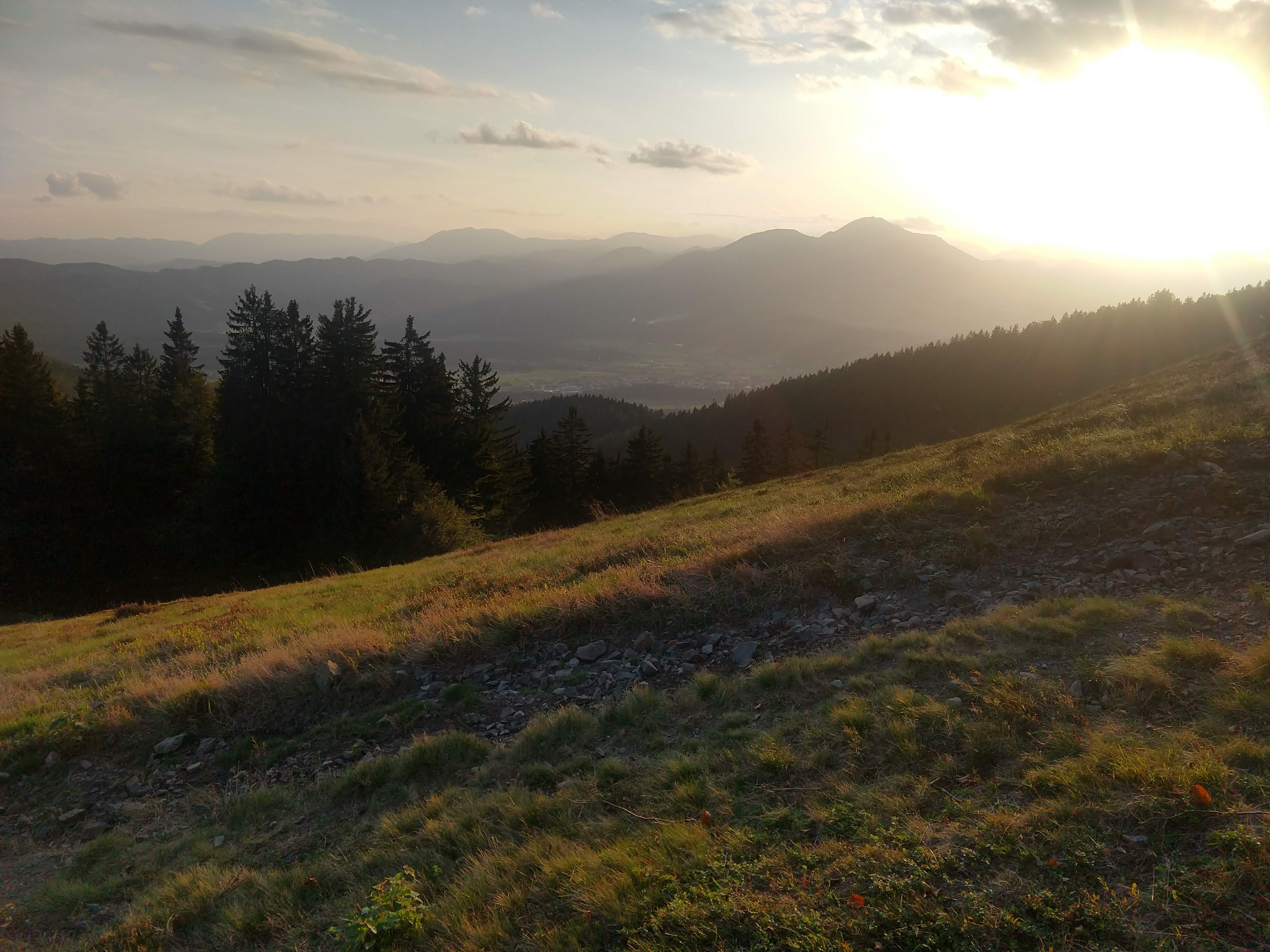
Following the stamp collection and looking at the map, I departed the Partizanski Dom at 1657, continuing on the marked and signed trail. This next segment really showed me some spectacular views that would be worth revisiting on another trip. A combination between the time of day and clarity looking westward and northward, as you can see in the photo gallery below. They are worth clicking and looking at each one though.
Eventually the views diminish as you make your way down the hill side on rugged forest roads and paths. Again, several different shrines are apparent along the way. The final stretch of hillside hiking was quite vivid and offered views down toward Slovenj Gradec.
Once you reach Jesenhov Vrh, the rest of the way to Slovenj Gradec is downhill. From the Vrh you make your way past a religious shrine, which is very elaborate (pictures below). A short distance from the Shrine is Koča pod Kremžarjevim vrhom. There were people present at the mountain hut but I did not go into it. By this point in the day, I was looking at the time and assessing the amount of available daylight remaining, which prompted me to continue on without breaking. In hindsight this might have been a good place to spend the night, but I had already made reservations at Hotel Slovenj Gradec so without eating the cost of the night, I opted to stick to the plan.


Koča pod Kremžarjevim vrhom – Slovenj Gradec (~3.28mile/5.29km)
Day 2: Section 9 General Route Day 2: Section 9 Elevation Profile


The last stretch of the day. All downhill from here and so close to a getting a real meal with the added benefit of geting this load off my feet and relax. I departed the mountain hut at 1843. I estimated that it should take 1.5-1.75hr to get to the hotel. The way down was a mixture between walking on the road (paved, dirt and rocky at different portions) and along normal trails that bypassed farm land of various livestock.
As I was making my way down the mountain side, I came across a farm with a man and his son offloading a bale of hay from a trailer. They kindly started talking to me and then asked if I wanted a ride done to the town.
Looking at the map I was probably half way to my destination. The time was later than I planned or desired and the daylight was almost completely gone. At this point my headlamp was almost needed to see the path in the woods and there wouldn’t be much in the open walking until I got closer to town. I took the man up on his offer as I talked with his son. They were both excited to meet an American.
Throughout this entire transaction I mostly communicated with the son because he knew English much better and we could exchange information much faster. After the bale of hay was off, I got into the truck. I know the common advice of “dont take rides from strangers” and I don’t normally hitch rides with strangers, but the farmer and his son seemed nice enough (from our brief interaction) and were looking to help me out.


The rest of ride the down to the town I attempted to talk to the man in what Slovene I knew, intermixed with English. From what I gathered he understood most of what I said. He was very interested about why I came to Slovenia and was so glad I was visiting and hiking in his beautiful country all the way from America. He was even more enthusiastic when I explained that I was part Slovene through my grandmother as well. The route he drove down can be seen in the GPS route (red) for this 9th section of the day where it deviates significantly from the yellow trail half way down.
After dropping me off near the town center (Glavni trg), I arrived at Hotel Slovenj Gradec at 1942. Had I walked instead of taken the ride, I probably would have arrived at least 30-45min later. Another good thing for the ride is the front desk was to closing at 8PM, though I found out later that I would’ve still been able to check in with the restaurant so all would’ve been good that night.
Daily Hiking Stats
- Total Distance: ~19.34miles / 31.12KM
- Estimated Elevation Gain/Loss: +4711ft / -7194ft
- Total time hiked: 10 hours 30 minutes
- Total Calories burned: 7000-8000 Cal
Night Time in Slovenj Gradec
After checking in at the Hotel, I headed to my room to begin washing my clothes so they could begin drying while I was getting dinner later. Following a shower, I headed down to check out what was in the area for dinner. It didn’t take long before settling on the Pizzeria on the main floor of the hotel.
The entire menu looked great at this point so I ordered something with some meat. I don’t recall which pizza I order it was but it tasted as good as the picture below looks. Union is one of the two major Slovenia beers, Laško being the other. Temno is just dark beer, where as the more common Union and Laško beers on tap are mostly lagers. Of all the receipts I accumulated along trip to help me rebuild it for these posts, this is the only one I don’t have so had to estimate that it cost 15-20 EUR. Beer is really inexpensive in Slovenia from what I’m used to paying in the US.
After dinner I walked around the town some, though it was notably chilly, but eventually went to my room to recharge and sleep.
Pica Union Temno


Lessons Learned
- Follow the signs and make sure you are heading in the right direction.
- Figure out what mountain huts are open and have food to help plan your sustenance for the day to keep you going. Had I known Ribniška was not open with food available, I might have spent less time there and more time at Grmovškov dom pod Veliko Kopo to combine food and rest.
Slovenian-English Translation
- Kava (Ka-vah) = Coffee
- Jezero/Jezera (yeh-zeh-ro/ra) = Lake/Lakes
- Vrh (v-ruh)= Top, Summit
- Črni (ch-r-ne) = Black
- Glavni trg = Main Market
- Pica (pe-ts-ah) = pizza
- Picerija (pe-ts-ah-re-ya) = Pizzeria
- Pivo (pe-oh) = Beer
- Temno Pivo (tim-no pe-oh) = Dark Beer
Current Trip Costs
- Transportation: 0 EURO
- Food: 28.2 -33.2EURO
- Lodging: 39.2 EURO
- Running Total Cost: 753.2 EURO
Previous Slovenia Posts
- Trip Planning: Slovenian Mountain Trail, part 1
- Slovenia Trip: Pre-Hike Days
- Slovenian Mountain Trail: Day 1
- Slovenian Mountain Trail: Day 2
- Slovenian Mountain Trail: Day 3
- Slovenian Mountain Trail: Day 4
- Slovenian Mountain Trail: Day 5
- Slovenian Mountain Trail: Day 6
- Slovenian Mountain Trail: Day 7
Useful Links
- Tourist Info for Maribor: https://www.visitmaribor.si/en
- Pohorje Information: https://en.wikipedia.org/wiki/Pohorje
- Beers in Slovenia: https://en.wikipedia.org/wiki/Beer_in_Slovenia
- Slovenj Gradec Info:
- Koroška Tourist info
- Very Useful offline map app of Slovenia (android link): https://play.google.com/store/apps/details?id=org.mapapps.mapyourtown.slovenia&hl=en_USGAIA App (android link): https://play.google.com/store/apps/details?id=com.trailbehind.android.gaiagps.pro
- Google Fi Phone Service: referral link
- Resources for learning Slovene
- https://www.slonline.si/ (great resource, free)
- Colloquial Slovene Book: Amazon Referral Link
- Colloquial Slovene Book-Audio clips: https://www.routledgetextbooks.com/textbooks/colloquial/language/slovene.php
- https://www.thinkslovenia.com/info-activities/slovenian-language-learning

