Summary
Sunday hike along the Lookout Mountain Trail in the Mt Baker-Snoqualmie National Forest in the North Cascades. This is a moderate-difficult, non-technical hike. There is considerable elevation gain along the entire route. The trail has several creek crossings in the the upper portion of the trail, with a varying range of quality and stability. The open slope just before getting to the Lookout hut offers excellent panoramic views of the valley and surrounding mountains to the east to southeast. The snow begins around the 5000ft line. The roughly 8.75 mile round-trip took about 7 hrs, with a break.
(All pictures are clickable for larger views.)
Route Overview

General Route Elevation Profile


In the above general route outline (yellow) was roughly our route. The trail is clearly defined the entire way, though in a couple of the snowy parts there was a little ambiguity. Snow tracks are likely visible.
Washington Trail Association Links:
- Lookout Mountain
Appropriate Maps:
- National Geographic Maps:
- North Cascades National Park #826
- Good overview of the area/surrounding area, but not practical for the details of the trail.
- North Cascades National Park #826
Overall Difficulty:
Moderate to strenuous. Lots of elevation gain. Not much snow until the last mile, which is on mostly steep terrain.
Gear Load-out:
- Gregory Zulu 40L [Amazon Link]
- Microspikes [Amazon Link]
- 3L Hydration Reservoir [Amazon Link]
- First Aid Kit
- Compass
- Map [Amazon Link]
- 1x pair extra socks (Darn Tough) [Amazon Link]
- Food
- Down Jacket [Amazon Link]
- Gloves (see Layered Glove post)
Getting to the Trailhead:
From Sedro Woolley, drive east along WA-20 for about 40 miles. WA-20 will begin to curve but continue straight to cross the bridge in Marblemount. Cascade River Rd is paved over the next 7miles to the trailhead. Once you reach the National Forest sign, the trailhead is about 0.4miles further. There are signs for the trailhead just before reaching the parking area on the right side of the road.
The parking area at the trailhead is decent. There is likely room for about 25 vehicles depending on how people park. There is no bathroom structure at the parking area.
Parking Area Trail Marker Incoming Road (Cascade River Rd)


Google Maps Directions:
From the North Cascades National Park facility in Sedro Woolley, WA to the Lookout Mountain Trailhead (click here)
Vehicle Clearance:
Cascade River Road is paved through to the trailhead with no issues for lower clearance vehicles.
Permits:
America the Beautiful National Parks/Forest or the Northwest National Forest Passes are valid. Normally you can get passes at the Ranger station in Marblemount, but it was closed when we were passing through. Your best bet is to get it from REI or through the National Forest Service website in advance.
Day Trip:
Pack Weight Start: Did Not Measure, est 10-15lbs.
Trailhead to Lookout-Monogram Lake Trail-split. 2hr 12min
We arrived at the parking area around 09:10 AM. There were 2 cars already there. The weather was sunny with clear skies and the temperature starting out was in the 50s.
For the first 30 minutes or so on the trail you experience a forest scenery. There is not much of a view of the adjacent mountains and ridges. You will notice a side-path heading towards a small area above a rock face bathing in the sunny that you can get your first views. The views are of the southern side of Lookout Mountain and the ridge to the south on the other side of the cascade river.


When you arrive at the meadow, you will be able to get some limited southern views when you turnaround throughout the clearing. The vegetation along the trail has been trimmed back a good bit from my last time hiking this. in 2019 (previous post). The trail is also very clearly defined and mostly free from fallen trees.


After crossing the small meadow, you will re-enter the woods. There is much less elevation gain to get to the Monogram Lake/Lookout Mountain trail split. Along the way, there are a couple water crossings.
The first bridge is solid, while the second has a lot of future potential. The short footbridges thereafter are pretty solid, though no major running water to worry about.
Lookout – Monogram Lake Trail Split


Lookout-Monogram Lake Trail-split to Fire Lookout. 3hr 59min (1hr 47min)
From the trail split, its a short jaunt to where you first encounter the lingering snow. There is not much snow to need anything for passage. You’ll cross a few log footbridges along the way and the trail does get a bit muddy from the melting snow. Although I mentioned the snow doesn’t start until about 5000ft, there were several short sparse areas with snow still on the trail from snowfall the week plus before.


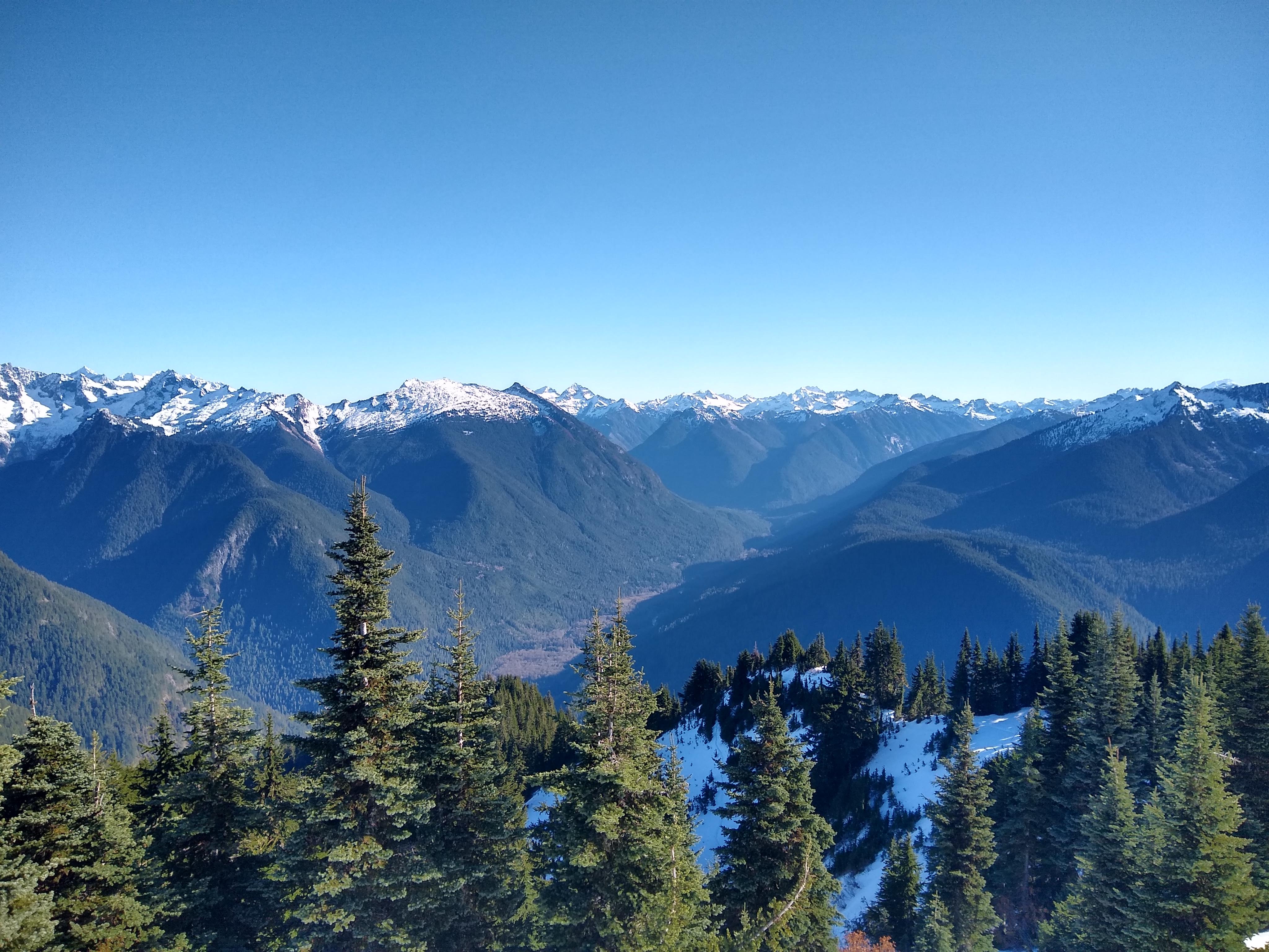
As we exited the forested area, the views really began to open up. As we crossed the open slope, the view down the valley and across toward the ridge above Monogram Lake began to open up more and more. With the clear skies, you could really see the mountains and ridges with extreme clarity.


As the trail switches back and forth up and across the side of the mountain, you get lots of views to the northeast to southeast. There are several spots when crossing the snow that are steep, which could be intimidating to some, are pretty secure and you likely wont face any issues.
You will likely want to use microspikes to maintain traction, especially on the way back down. The chance of avalanche at the time was pretty minimal since it looked like an earlier small one significantly reduced the snow build up on the steep areas above.


The map and elevation profile below roughly depicts where the the snow really begins on the final ascent. Red highlight behind the yellow route.


After working our way across the snow, we could see the tower getting closer and closer. Once we hit the final prominent switchback you generally walk along the ridge up to the tower. At that point you also have a great view to the south and southwest.


The final stretch to the tower.


Fire Lookout Break (28 min)
Mt Baker (far background) Northern View Northeastern View Northeastern View Eastern View Eastern View Southeastern View Southwest View West View


Inside the Fire Lookout and lunch.
Peanut Butter, Nutella, Oatmeal and Pumpkin seed sandwich


Fire Lookout to Trailhead. 6hr 44min (2hr 17min)
The return trip back to the trailhead went by much quicker. It took roughly 30 minutes to get from the Fire Lookout back to the start of the main forest area after the large open hillside. There were a few people that were making their way up to the tower as we made our way down.
Along the way you get some peak-a-boo views but they are few and far between after you re-enter the forest. The forest floor being less rocky for the most part, make this an easy on the knees trail as well.
We got to the end of the small meadow around 1hr 30min. From there its about 45mintues back down to the parking lot.
Trip Metrics
- Total Mileage: ~8.74 miles
- Total Elevation: ~4707 ft
- Start Time: ~09:20 AM Sunday 1 November 2020
- Finish Time: ~4:05 PM
- Total Time: 6hr 44min (28 min break)


The scenery is gorgeous! Was the lookout station stocked?
No. The lookout station is pretty basic, but it will keep you warmer and protected from the elements in an emergency.