Summary
Sunday morning hike along the Maple Pass Loop trail in the Okanogan National Forest in the North Cascades. You can either go clock-wise or counter-clockwise, although I took the counter direction. This is a moderate, non-technical hike. The trail gains elevation steadily up to the North Cascades National Park Boundary . Most of the hike offers panoramic views of the surrounding ridges and valleys in the central/eastern portion of the North Cascade. At the upper portion of Maple Pass, you get excellent 360 views of the local region. There were a few patches of snow along the upper ridge line, but nothing complicated. The roughly 7.2 mile round-trip took less than 3.5hrs.
(All pictures are clickable for larger views.)
Route Overview
Expand for more details


In the above general route outline, the yellow was roughly the route. The trail is clearly defined the entire way.
Washington Trail Association Links:
- Maple Pass Loop Trail
Appropriate Maps:
- National Geographic Maps:
- North Cascades National Park #826
- Good overview of the area/surrounding area, but not practical for the details of the trail.
- North Cascades National Park #826
Overall Difficulty:
Moderate. The trail is well defined but depending on which direction you take will determine how steep you climb up to the pass. Counter-clockwise will yield a decent grade the entire way, a lot of which is rocky. Clock-wise, is a fast ascent due to the steepness but less rocky.
Gear Load-out:
Expand for more details
- Gregory Zulu 40L [Amazon Link]
- Microspikes [Amazon Link]
- 3L Hydration Reservoir [Amazon Link]
- 2.5L Hydration Bladder Reserve (for added hiking weight)
- First Aid Kit
- Compass
- Map [Amazon Link]
- 1x pair extra socks (Darn Tough) [Amazon Link]
- Food
- Light Down Jacket
- Light-weight warming layer
- Gloves (see Layered Glove post)
Getting to the Trailhead:
Expand for more details
From the central part of the Newhalem town, drive east along WA-20 for about 36.9 miles. There is a light brown sign indicating the turn for NF-600/Heather-Maple Pass is coming up on your right (as you head East). The road takes you to the parking area and trailhead.

one-way loop


The parking area at the trailhead is quite large. There is likely room for 40+ vehicles depending on how people park. There are a couple bathroom structures at the parking area.
Google Maps Directions:
From the Newhalem Town/Information area in Newhalem, WA to the Maple Pass Trail Trailhead (click here)
Vehicle Clearance:
The road is paved the whole way with no issues needing high clearance.
Permits:
America the Beautiful National Parks/Forest or the Northwest National Forest Passes are valid. If you don’t bring your pass, or just don’t have one, there is a pay station post near the trailhead post board.
Restrooms:
There are restroom structures at the parking area.
Day Trip:
Pack Weight Start: Did Not Measure, est 25lbs.
I arrived at the parking area around 9:50AM. The parking area had plenty of parking and there is an larger parking area as you drive around the parking loop. There were a couple other small hiking groups that had arrived around the time I arrived, but the trail was not overly busy. Arriving after 1-2PM is probably good if you cant make it early in the morning because the parking area will fill up, especially on nice weekends. The weather was in the mid 60s in the parking area, and remained below 70 for most the hike.
Trailhead to Lower Ridge Line of Maple Pass. 1hr 24min
At the trailhead there are some signs with various information and maps about the hikes, permitting and rules of use. Please be responsible and pickup after yourself! It’s not a difficult task, but evidence seems to prove otherwise.


I had decided to go counter-clock-wise along the trail as I had seen mentioned in a couple of the WTA trail reports. Starting out you work your way up through the woods over a couple of switchbacks. Soon enough, you’ll get out in the open, which allows you to see much more of the surrounding area as you ascend.


Eventually you’ll come to a split in the trail to either continue to Maple Pass (right) or proceed to the Lake (left). I continued on the right of the split. As you gain more elevation, you get a good vantage point of the lake below, which continues the remainder of the loop.


Along the way your encounter some open areas with lots of wildflowers that brighten up the usual gray and green.


Examples of the panoramic views you’ll get. Sometimes you need to turnaround and take in what you’re not facing on the way up.


Once you reach the North Cascades National Park Boundary sign, its a good spot to take a break and observe Corteo Peak in the background, if the clouds are high enough of course. During this particular day the clouds seemed to rise and fall throughout the morning, which obscured the view of the surrounding and background peaks and ridges.


Lower Maple Pass to Upper Maple Pass. 1hr 56min (32min).
From the western side of the pass, you’ll begin traversing eastward along the ridge to the upper portion of Maple Pass. The next collection of pictures will depict some of the sights along the way. The white rope along sections of the path are intended to keep hikers off areas undergoing restoration. Please be conscientious and respectful.
Marmot!


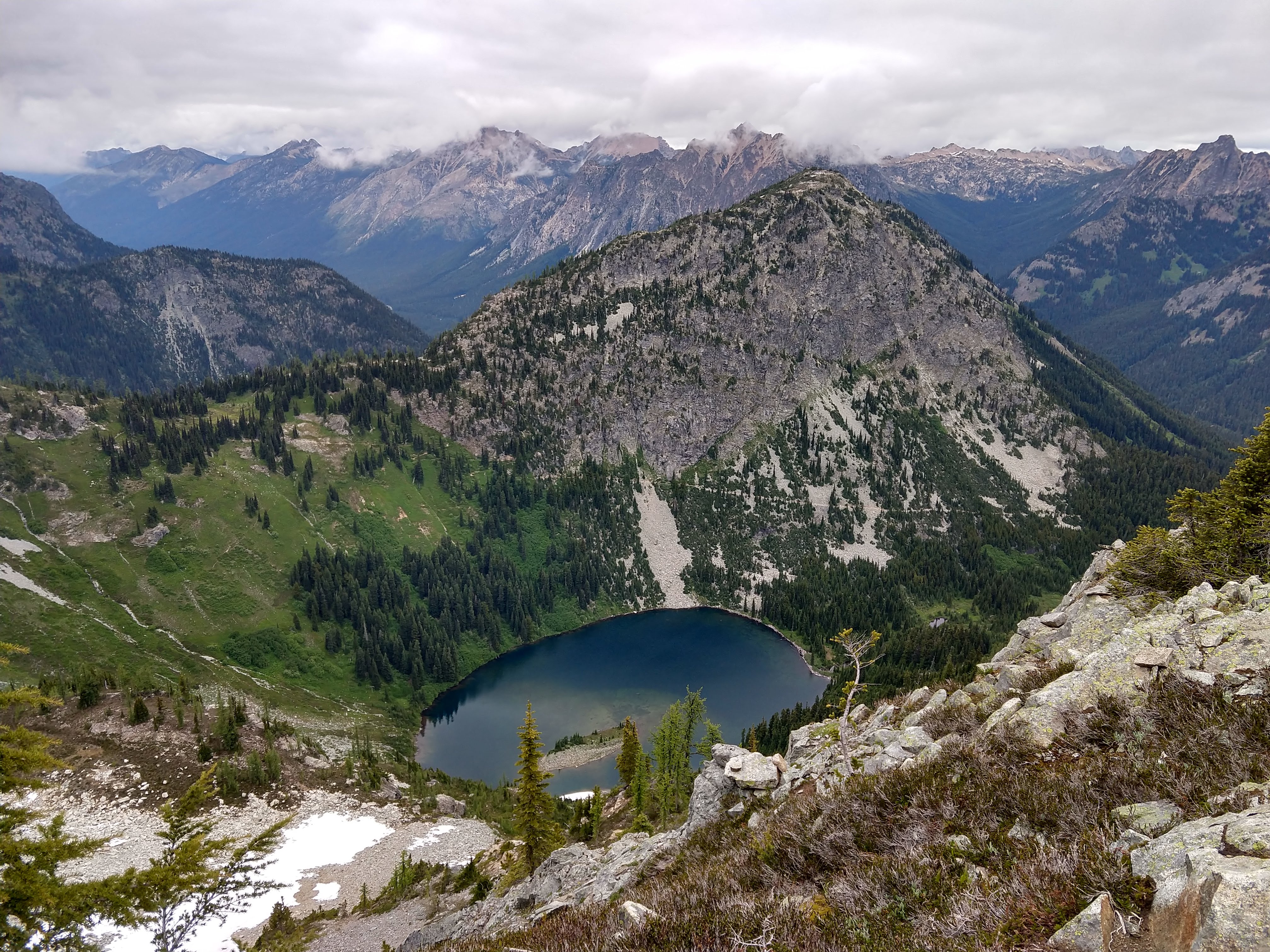
Once you reach the other North Cascades National Park Boundary sign, you’ll know you’re at the opposite side of the pass before the trail begins to descend back toward the parking area. This is another great place to break and provides a better vantage point of the Ann Lake, as well as the areas west and north.
I ended up taking a break and matching up the map with my surroundings. The temperature was much cooler at this spot and was refreshing with the pack off.
Maple Pass to Trailhead. 3hr 22min (1hr 14min)
After wrapping up my break, I estimated the trip back would take about 1.5hrs since it would be all downhill. As you descend you’ll get several views of Rainy Lake, but not are as clear and unobstructed as the views of Ann Lake.


Once the dirt path intersects the asphalt path, keep left and continue the trail back to where the trail begin.


I arrived back at the car around 1:35PM, roughly an hour and a quarter, which was faster than I expected.
Trip Metrics
- Total Mileage: ~7.2 miles
- Total Elevation: ~2000ft
- Start Time: ~10:12PM Sunday 7 July 2019
- Finish Time: ~1:35PM
- Total Time: 3hr 22min
- Total Calories: 2215


Cute little marmot! Breathtaking scenery.