Summary
Sunday afternoon hike to the Park Butte Lookout in the Mount Baker Wilderness in the North Cascades. This is a moderate, non-technical hike. The trail gains elevation steadily up to the Lookout hut. The entire hike offers panoramic views of the surrounding ridges and valleys West, South and East, as well as a great northern view of the south side of Mount Baker. At the Lookout, you get excellent 360 views of the North Cascades region south of Mount Baker. There was a decent amount of snow after about 2.2miles along the trail. Microspikes would be advised, but maybe not necessary for most parts. The roughly 7.5 mile round-trip took about 5 hrs 10min, which included about a 1 hour and 20 minutes break at the Lookout hut.
(All pictures are clickable for larger views.)
Route Overview
Expand for more details


In the above general route outline, the yellow was roughly our route. The trail is clearly defined the entire way until the last 0.3 miles. Snow tracks might be visible.
I used the Gaia app to track my return route to help outline the general route depicted above.
Washington Trail Association Links:
Appropriate Maps:
- National Geographic Maps:
- Mt Baker, Boulder River Wilderness Area, Mt Baker-Snoqualmie National Forest #826
- This provided a good overview of the area/surrounding area, but would not be practical for the details of the trail.
- Mt Baker, Boulder River Wilderness Area, Mt Baker-Snoqualmie National Forest #826
- Green Trails Map:
- Mount Baker Wilderness, Map 13SX *** Best Map for the Hike ***
- This was the best map for this hike and area. There is a lot more fidelity to the trail features and switchbacks.
- Contours are much easier to see.
- Mount Baker Wilderness, Map 13SX *** Best Map for the Hike ***

Overall Difficulty:
Moderate. The initial trek through Schriebers Meadow is pretty flat but begins to increase in the northern portion. From here it is a general 10-30% grade most of the way to Park Butte Lookout. As you near the Railroad Grade Trail and Park Butte Trail split, the snow is pretty consistent up to the Lookout. Although microspikes are not absolutely necessary, it will help you maintain traction.
Gear Load-out:
Expand for more details
- Gregory Zulu 40L [Amazon Link]
- Microspikes [Amazon Link]
- 3L Hydration Reservoir [Amazon Link]
- Ice Axe [Amazon Link]
- Glacier Glasses [Amazon Link]
- 2.5L Hydration Bladder Reserve (for added hiking weight)
- First Aid Kit
- Compass
- Map [Amazon Link (Green Trails)]
- 1x pair extra socks (Darn Tough) [Amazon Link]
- Food
- Light Down Jacket [Amazon Link]
- Light-weight warming layer
- Gloves (see Layered Glove post)
Getting to the Trailhead:
Expand for more details
From Sedro Wooley, drive east along WA-20 for about 16.3 miles. You will see a brown sign indicating the turn for Baker Lake is coming up on your left. Turn left onto Baker Lake Road and continue north for about 12.2 miles. There will be a dirt road to your left once you cross the bridge. Turn left here and continue along NF-12 for about 3.5 miles. Stay left at the first road split roughly a mile from the initial turn onto NF-12. Around the 3.5 mile area, you will see a sign for NF-13 heading to your right. Turn right here and follow the road up to the trailhead. The road dead-ends at the parking lot and trailhead, so you can’t miss it.

The parking area at the trailhead is quite large. There is likely room for 40+ vehicles depending on how people park and if the center area is utilized. There is a bathroom structure at the parking area.


Google Maps Directions:
From the North Cascades Institute in Sedro-Woolley to the Mt Baker NRA Trailhead (click here)
Vehicle Clearance:
I drove a truck with no issues. You could take a lower clearance vehicle but watch out for the deep and numerous potholes. The potholes shouldn’t be an issue to straddle or drive around them if you have a low clearance vehicle. The road is also generally wide enough in most areas for 2 way traffic. In the areas were the road is more narrow there are not always pull-off areas, but you’ll notice where they are.
Permits:
America the Beautiful National Parks/Forest or the Northwest National Forest Passes are valid. If you don’t bring your pass, or just don’t have one, there is a pay station post near the trailhead signs and bathrooms.
Restrooms:
There are two restroom structures at the parking area.

Day Trip:
Pack Weight Start: Did Not Measure, est 20lbs.
I arrived at the parking area around 1:10PM. Hiking groups were starting to trickle to the parking area and departing. I had no trouble finding a parking spot. Arriving after 1PM is probably good if you cant make it early in the morning because the parking area will fill up, especially on nice weekends The weather was in the mid 60s in the parking area, and remained that way for most the hike, while gradually getting cool the last stretch to the Lookout and return trip.
Trailhead to Trail Split. 56min


At the trailhead there are some signs with various information and maps about the hikes, permitting and rules of use. Please be responsible and pickup after yourself! It’s not a difficult task, but evidence seems to prove otherwise at times…
Starting out along the trail, you meander through a semi-open meadow that runs relatively flat. The trail is well traveled and defined. As you make your way north along the trail you’ll observe Loomis Mountain to the south and Survey Point due West.

Loomis Mountain Survey Point


The trail begins to turn very rocky as it approaches the water flow area. There is a decent creek crossing but there is a fine narrow sturdy bridge, that’s limited to 500lb, though its best to limit 1 person crossing at a time. Once you cross the bridge and get to the tree line on the other side you can get a good view looking down the creek valley.
From here, the trail begins to generally increase in slope but isn’t necessarily as rocky as the first section. Around the 2mile mark you’ll come upon a split in trail where the Scott Paul Trail connects to the Park Butte Trail. Keep left at this intersection (follow the sign post). From here it’s only about 0.4 miles to the trail split where Park Butte Trail and Railroad Grade head their separate ways. Along this section, you begin to encounter snow and begins to expand its coverage. The sign post at the trail split was clearly visible during my hike.
foot bridge Park Butte-Scott Paul Trail Intersection Park Butte-Railroad Grade Trail Split


Trail Split to Lookout Hut. 2hr 8min (1hr 12min)
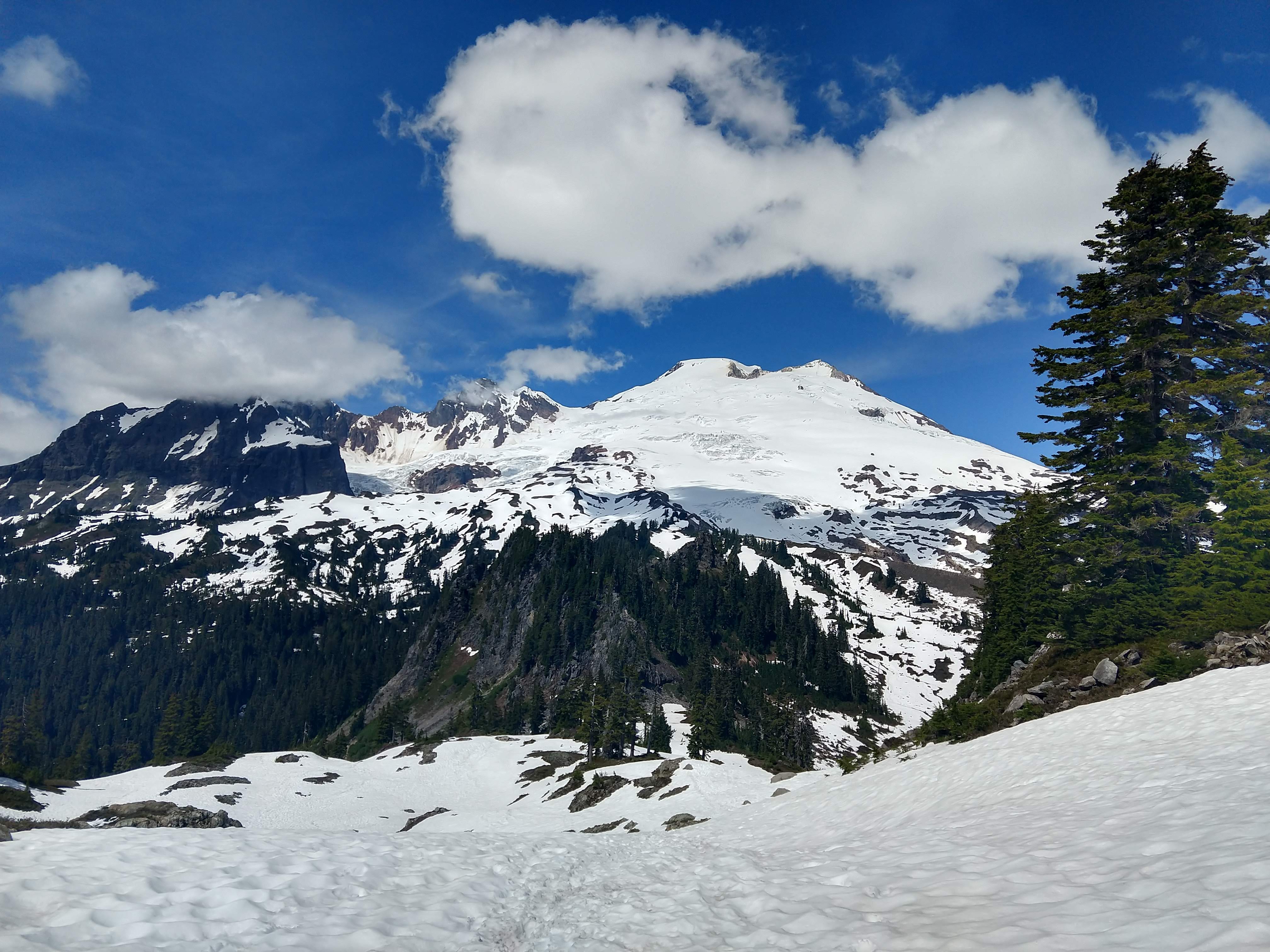
Keep left at the sign post toward Park Butte. As you work your way through the gentle grade in snow, you’ll begin to ascend near the base of Cathedral Crag. From this point on its all up hill to the Lookout. Be sure to look back at Mount Baker, Colfax Peak, Lincoln Peak, Seward Peak, and Lee Promontory.
Also just passed the trail split for Bell Pass Trail-Park Butte Trail, I put on my microspikes to keep from sliding around as much on the snow. I didn’t think they are required to make it to the Butte, but they were helpful in maintain traction.
Panoramic with Cathedral Crag in middle Trail split for Bell Pass Trail/PNW Trail and Park Butte Last good view before being obscured by clouds Final Stretch!


The last stretch (as seen in the picture above) takes maybe 10mintues.
Long Break at the Lookout Hut 3hr 31min (1hr 23min)
Since I had nothing going on the rest of the day and no one appeared to be following me along the trail, I thought I would just hang out and take in the views at the Lookout Hut. By the time I arrived, clouds had formed between Park Butte and Mount Baker. I had thought I would be able to wait it out for some good photography of the mountain, but clouds just didn’t cooperate this time.
That was alright because I didn’t mind the abundance of other views besides Mount Baker. It also gave me lots of time to really compare the map with what I was observing in the region.
Northern Views


Western Views
Middle Fork Nooksack River Twin Sisters Range Twin Sisters Range


Southern Views


Eastern Views


Lookout to Trailhead. 5hr 10min (1hr 39min)
After I had my time at the Lookout enjoying the views it was getting close to 5PM, so I thought it was about time to head back.
The rest of the pictures capture the return trip back to the parking area.
Look back toward the Lookout Slide chute Cathedral Crag Last good view of Mt Baker on the way back


I arrived back at the truck around 6:35PM, roughly an hour and a half, which was roughly what I estimated when I departed the Lookout Hut. Most of the vehicles had cleared out of the parking area already.
I will definitely be returning to check out Railroad Grade as far as I can make it without getting into technical mountaineering. Cathedral Point and Park Butte would make from some excellent camping areas as well.
Trip Metrics
- Total Mileage: ~7.5 miles
- Total Elevation: ~2270 ft
- Start Time: ~1:16PM Sunday 16 June 2019
- Finish Time: ~6:35PM
- Total Time: 5hr 10min
- Total Calories: 3147

