Summary
Sunday hike along the northern portion of the Baker Lake Trail (#610) in the Mt Baker-Snoqualmie National Forest in the North Cascades. This is a easy, non-technical hike. There is minimal elevation gain along the entire route. The trail skirts along the eastern bank of Baker Lake the entire way from the southern trailhead to the northern trailhead, with several areas to get views of Mt Baker and Mt Shuksan, as well as the surrounding northern and eastern areas. There are several places to camp along the trail at designated campsites, which also have heavy-duty bear boxes. The weather was great the entire day with mostly clear skies and decently warm temperatures the entire way. There were several groups of hikers on the trail during the whole outing. The 16.3 mile round-trip segment took about 6.25 hrs.
(All pictures are clickable for larger views.)
Route Overview
Expand for more details

In the above general route outline, the yellow was roughly our route. The trail is clearly defined the entire way.
I used the Gaia app to outline the general route depicted above.
Washington Trail Association Links:
- Baker Lake,North
Map
- Mount Baker Wilderness, Map 13SX *** Best Map for the Hike ***
- This was the best map for this hike and area. There is a lot more fidelity to the trail features and switchbacks.
- Mileage is displayed for each of the trail sections and accurate
- Contours are much easier to see.
 |
| $16 |
Overall Difficulty:
Easy. Minimal elevation gain. No snow. The mileage can easily be extend to the Baker Lake South (previous trip post) trailhead at the southern end making it a 14mile one-way hike or 28mile round trip day hike.
Gear Load-out:
Expand for more details
- Osprey Talon 33L
- 3L Hydration Reservoir
- First Aid Kit
- Compass
- Map
- 1x pair extra socks
- Food
Getting to the Trailhead:
Expand for more details
From Sedro Wooley, drive east along WA-20 for about 16.3 miles. You will see a brown sign indicating the turn for Baker Lake is coming up on your left. Turn left onto Baker Lake Road and continue north for about 26 miles. Its a paved road up to around the 20mile mark. After that, its gravel and dirt until you get to the trailhead parking area. The road deadends into the parking lot and trailhead, so you can’t miss it.
The parking area at the trailhead is quite large. There is likely room for 40-60 vehicles depending on how people park and if the center area is utilized. There is a bathroom structure at the parking area.

Google Maps Directions:
From the North Cascades National Park facility in Sedro Woolley, WA to the Baker Lake (North) Trailhead (click here)
Vehicle Clearance:
NF-11 is paved for about the first 20 miles. Just past the Swift Creek Camp/Boating area, the road becomes dirt and gravel with several pot holes over the next 6miles to the trailhead. A high clearance vehicle would be easy but a compact/lower clearance vehicle could make it.
Permits:
America the Beautiful National Parks/Forest or the Northwest National Forest Passes are valid. They have day pass fee envelops at the trailhead if you have neither pass.
Day Trip:
Pack Weight Start: Did Not Measure, est 10lbs.
Trailhead to Noisy Creek Campsite. 1hr 36min

When we arrived at the parking area about 10AM, there were several vehicles in the parking area. The starting temperature was in the low/mid-70s in the parking area and mostly clear skies.
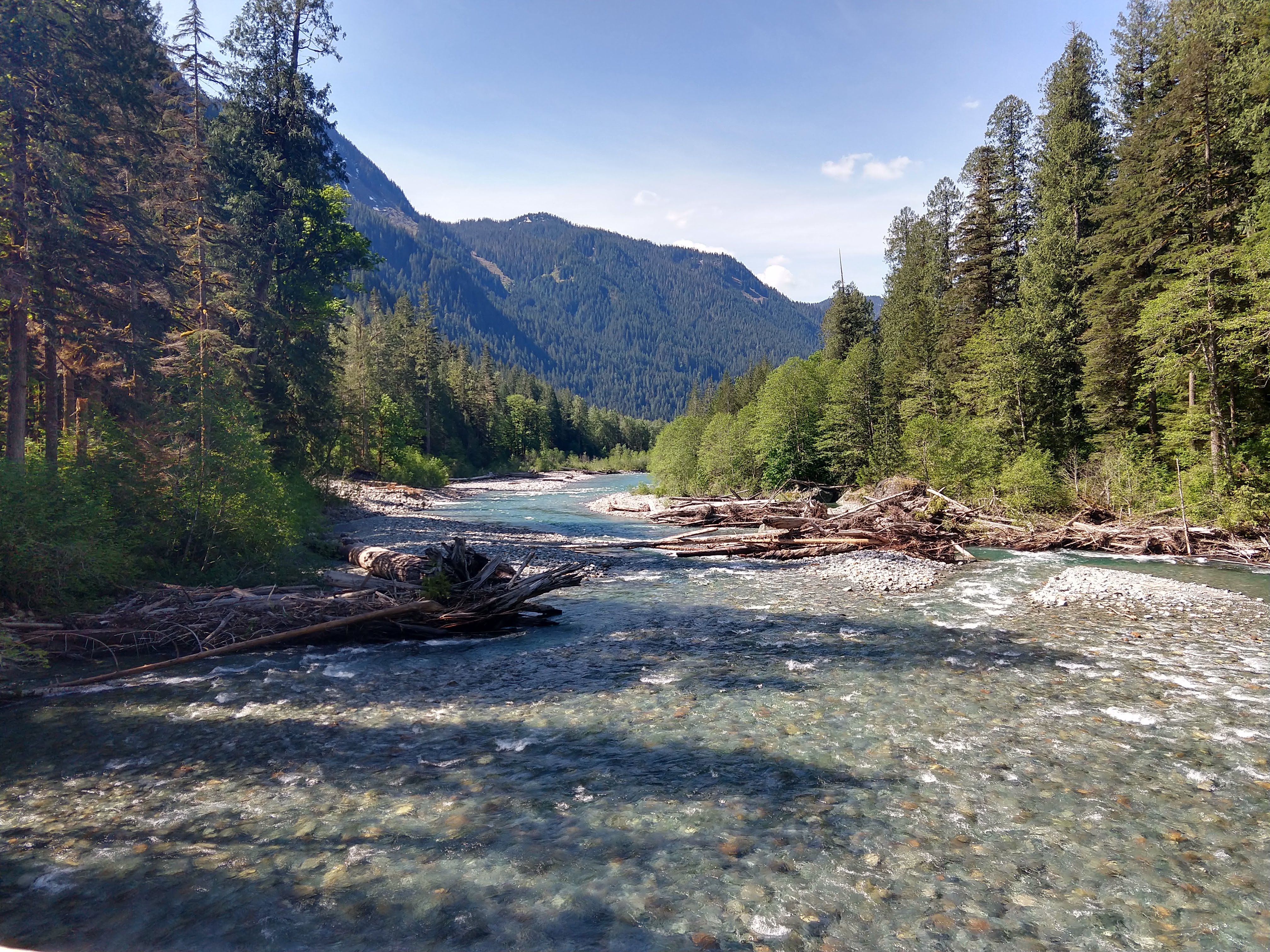
Starting out from the trailhead, after about 0.6 miles you come to the first of four or five bridges. This bridge is crossing the Baker River, which flows from the north down into Baker Lake.

Baker River


From the bridge to the Noisy Creek Campsite is about 4 miles.
Blum Creek


This next bridge area had some good views of the water rushing down Hidden Creek. The temperature was noticeably cooler in the center of the bridge, which felt pretty good on the way out and the way back.
Hidden Creek


Between Hidden Creek and the Noisy Creek Campground, there are 3 additional creeks you need to cross. The water was low enough that crossing any of them wasn’t difficult. As you can see from the pictures below of the trail and views, there are several areas where you can get some views toward Mt Baker and Mt Shuksan.
There aren’t many areas along the trail where you get full clearings so you’ll need to make do with what the trail provides. As you follow the trail through the woods, there is plenty of moss covered trees and lush vegetation surrounding the path.


Once we arrived at the Noisy Creek Camping area, we walked around the area to catch some of the views along the shore. The pictures below give you an idea of some of the available views.


There are solid bear boxes and fire rings with cooking grates at the camping area. Each of the sites has a table as well. There are plenty of flat areas for tents as well. It looked like there were two primary campsites in the area, each with their own bear box, table and fire ring. I did not take pictures of all the camping areas but you can get the gist from the ones below.


Noisy Creek Campsite to Silver Creek Campsite. 2hr 24min (48min)
The next section to Silver Creek is only about 1.3 miles. A lot of the trail is more of the same as the previous 4 miles. Several peak-a-boo spots, a couple of creek crossings.
Noisy Creek Silver Creek


The Silver Creek Campsite is much smaller than Noisy Creek. There is probably enough room for 2-3 small groups (~1 tent per group) or 1 large group. The campsite is first come, first serve as far as I am aware.


Silver Creek Campsite to Turnaround. 3hr 15min (50min)
Initially, we thought Silver Creek camping area would be a simple goal, but once we got there we felt like putting on some additional mileage. We figured we would at least walk to the bend in the trail where Baker Lake makes a sharp turn to the south. Were were thinking that there might be some views, but there wasn’t much.
After getting about halfway between Maple Grove and Silver Creek (roughly 8.25miles from the parking lot), we turned around to head back. The pictures below depict the general area we stopped, although there was nothing particularly special or unique about this turnaround area.


Returning to Parking Lot. 6hr 15min (3hr)
The return trip was definitely warmer the entire way, so at each bridge and creek crossing we look a little time extra time to cool off and eat some food. As we approached each, you could tell the temperature was falling the closer you got. Each of the creeks would be excellent sources of water if you needed to top up along the way as well.


Trip Metrics
- Total Mileage: ~16.3 miles
- Total Elevation: <1000 ft
- Start Time: ~10:09AM Sunday 19 May 2019
- Finish Time: ~4:24PM
- Total Time: 6hr 15min


Super pictures and narrative!