
Summary
Saturday morning day hike along the southeastern shore of Baker Lake in the Mt Baker-Snoqualmie National Forest with a friend. This is a non-technical hike with minimal elevation gain from trailhead to Maple Grove, making this pretty easy going hike and perfect for beginners or easy mileage training. The weather when we started out was was clear skies with dense misty clouds above the lake but cleared up throughout the morning into the afternoon. The temperature was quite brisk when we started but warmed up by the time we departed Maple Grove for the return trip. There was a moderate amount of hiker traffic due to great weekend conditions. The hike took us about 3hr 20min, which included about a 30min break at Maple Grove to take in the views of Mt Baker, Mt Shuksan and general Baker Lake surroundings.
Route Overview

General Trail to Maple Grove Baker Lake-Maple Grove Elevation Profile


Washington Trail Association Links:
- Baker Lake Maple Grove
Appropriate Maps:
- National Geographic Maps:
- Mt Baker, Boulder River Wilderness Area, Mt Baker-Snoqualmie National Forest #826
- Good overview of the area/surrounding area, but would not be practical for the details of the trail.
- Mt Baker, Boulder River Wilderness Area, Mt Baker-Snoqualmie National Forest #826
- Green Trails Map:
- Mount Baker Wilderness, Map 13SX *** Best Map for the Hike ***
- This was the best map for this hike and area. There is a lot more fidelity to the trail features and switchbacks.
- Mileage is displayed for each of the trail sections and accurate
- Contours are much easier to see.
- Mount Baker Wilderness, Map 13SX *** Best Map for the Hike ***
|

Overall Difficulty:
Easy during all sections. This trail is pretty rolling and gradual and ideal for those starting out or training on easy mileage. The mileage can easily be extend to the Baker River trailhead at the northern end making it a 14mile one-way hike or 28mile round trip day hike.
Gear Load-out:
- Marmot day pack [Amazon Link]
- 3L Hydration Reservoir [Amazon Link]
- First Aid Kit
- Sunglasses [Amazon Link]
- Down Jacket [Amazon Link]
- Light rain jacket [Amazon Link]
- Beanie
- Gloves (see Layered Glove post)
- Compass
- Map
- 1x pair extra socks (Darn Tough) [Amazon Link]
- Food
Getting to the Trailhead:
From Sedro Wooley, drive east along WA-20 for about 16.3 miles. You will see a brown sign indicating the turn for Baker Laker is coming up on your left. Turn left onto Baker Lake Road and continue north for about 14.1 miles. Shortly after you pass a Forest Service building and small gravel parking area, you will turn right onto NF-1112. Its a paved road all the way to the Hydroelectric Plant facility. From the facility to the trailhead is about 1.8miles.
Continue past the facility. The road will narrow leading up to the dam crossing. Cross the dam. There is only enough space (width) for a single vehicle to cross at a time in each direction. Once you finish crossing the dam, continue on the road. At the gated road (Private Property) stay left. From the gate to the trailhead is about 0.8miles.
The trailhead is clearly marked. You cant miss the parking area and there is a trailhead sign visible (see top picture). There is somewhat plenty of parking but it really depends on how much space people think cars need. Park smartly so others can enjoy the trail as well. There is a maintained bathroom structure, but you may want to bring toilet paper just in case.
Google Maps Directions:
From North Cascades National Park Ranger Station in Sedro-Woolley, WA to the Trailhead (click here)
Vehicle Clearance:
I have driven both my commuter car and a truck to the trailhead with no issues, but watch out for fallen rocks and potholes if you have a low clearance vehicle. The potholes shouldn’t be an issue to straddle or drive around them if you have a low clearance vehicle. The road is also generally wide enough in most areas for 2 way traffic. In the areas were the road is more narrow there are plenty of small pull-off areas in both directions.

Permits:
You do need a National Parks/Forest or Northwest National Forest Pass for this area. Display appropriately as this trailhead is much more accessible and likely to be visited by the Forest Service.
Day Trip:
Pack Weight Start: Did Not Measure, est 10lbs. No picture.
Baker Lake South Trailhead to Log Bridge. 0hr 26min.
Starting at 1020, the parking lot had 4 vehicle. The weather was brisk and the sky was clear. The initial part of the hike is through semi-dense forest with little to no views. During the first section you cross several small bridges and streams flowing across the trail. The wood bridges were a little slick from the cold/freezing temperatures and ambient moisture. As you walk along the trail, you will notice a lot of heavy moss on the surrounding trees and lush green ferns leaving the forest floor mostly covered.
It was a very quiet morning. We mostly encountered a couple of people along the trail to the log bridge. There were only a few cars in the parking lot though, one of which showed up just before we did. The streams draining down to the lake were the biggest contributor to noise but between streams there was plenty of space for stillness and silence. All along the trail you can look mostly down hill toward the lake but its mostly obscured by the dense trees. The trail generally follows along a contour line but does have some ups and downs along the way
When we got to the log bridge we decided to venture down stream to where the stream was flowing into the lake. Since the water level of the lake was quite low we were able to go out some distance. If you do decide to go down as well, be cautious stepping on the rocks because they are quite smooth and slippery.
Looking back at the log bridge Looking toward the lake The Stream Baker Lake, morning mist Baker Lake, morning mist Baker Lake, morning mist


Log Bridge to Anderson Point area. 0 hr 44 min. 404 cal.
Once you cross the log bridge, Anderson Point is not much further down the trail. It would be very difficult to miss Anderson Point with its large, maintained sign. If you are going to camp out at Anderson Point, continue down the trail until you see some clearly marked camping areas with solid Bear Boxes.
Log Bridge Fast moving creek Anderson Point turnoff


Anderson Point area to Maple Grove. 1hr 24min (0hr 40 min). 796 cal (392 cal difference)
From Anderson Point to Maple Grove there isn’t much different to view along the way. More trees covered in dense moss. There are a lot less stream crossings during this section and the topography is a little more gradual in comparison to the steep hillside to your left and right on the first section to Anderson Point.
You will know when you hit Maple Grove because you can’t miss the huge sign along the trail that continues north to Silver Creek. Silver Creek is the next designated campsite area along the trail and is about 4.5 miles from Maple Grove.
Maple Grove turnoff

Its a pretty short trail from the Maple Grove sign to the camping areas and beach. The various camp sites do have solid Bear Boxes, so if you are considering camping here, there should be no need to carry a bear-proof canister. There are 2 backcountry restroom facilities (signage along the trail). Be respectful of the restrooms as they likely aren’t serviced routinely and are the only major ones between here and the trailhead.
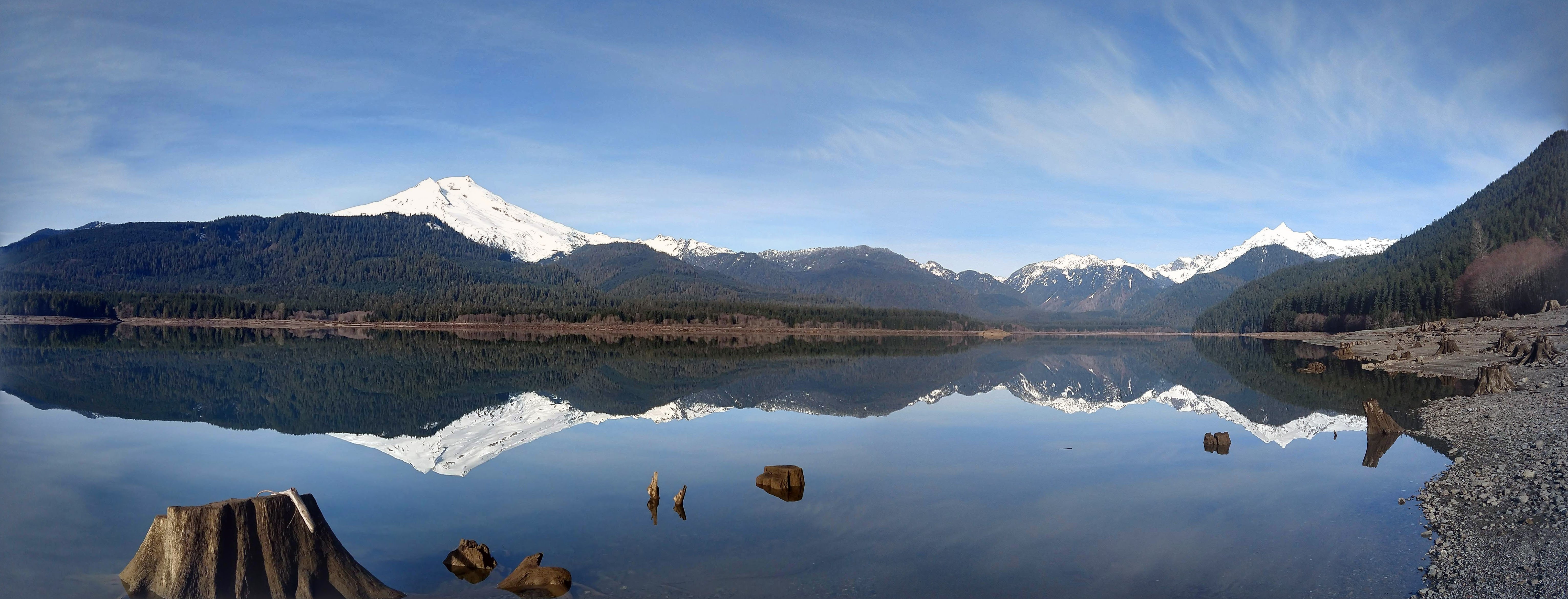
Once you get to the beach area, you can see all the tree stumps that would normally be submerged in the lake, but due to the low water level of the lake the beach extends much further out. This makes for some great panoramic views of the Baker Lake region. There are a couple of solid picnic tables as well along the beach area for those planning something more than trail mix and nature bars.
The photos below give you views facing westward of Baker Lake starting with the southern view and working your way north to Mt Shuksan.
Southwestern View Mt Baker W-NW View Mt Baker N-NW View N-NW to North toward Mt Shuksan North toward Mt Shuksan


Maple Grove to Trailhead. 3hr 20min (1hr 36min). 1818 cal (855 cal difference).
The return trip back to the trailhead was not very eventful and we generally kept a steady pace. The temperature was a little warmer by the time we started heading back and stayed very comfortable the rest of the way back.
On the way back we saw a few groups that were heading to Maple Grove or further for some good overnight camping. Maple Grove, while the water level is very low, would be a great spot to stargaze on the beach area on any clear night. There would be practically no light population due to its location and has a wide field of view. The evening sunset would cast colorful arrays on the snow covered Mt Shuksan and Mt Baker. Something to consider when the weather clears up over another weekend.
We did not take any breaks along the return trip as we were not feeling any exhaustion and the mileage was pretty easy given the lack of elevation gain. When we got back to the parking area, the parking lot was full and people were parked above and below the parking area (noticeable wide shoulder areas).
Trip Metrics
- Total Mileage: ~7.2 miles
- Total Elevation: ~500ft
- Start Time: ~1022 Saturday 26 January 2019
- Finish Time: ~1343
- Est Calories: 1818
– – – – – – – – – – – – – – – – – – – – – – – –

