
Summary
Sunday morning day hike to Excelsior Peak in the Mt Baker-Snoqualmie National Forest with a friend. This is a non-technical hike that is moderate to strenuous, particularly with the snow accumulation beginning around 3500ft. There is an avalanche region when you get out of the tree line and approach the Pass area. You gain about 3640ft of elevation to the peak over the course of 4.5miles, but the 360 views at the top are worth the trip. The weather cooperated with us, giving us clear skies above a certain elevation so our peak views were unencumbered. The temperature was likely in the upper 30s/low 40s in the parking area and lower 30s at the pass/peak. There was 10-15 hikers that we encountered throughout the day on the trail. The hike took us about 5hrs.
Route Overview

Generalized Route Overview Genarlized Elevation Overview


Washington Trail Association Links:
- Excelsior Pass
Appropriate Maps:
- National Geographic Maps:
- Mt Baker, Boulder River Wilderness Area, Mt Baker-Snoqualmie National Forest #826
- Good overview of the area/surrounding area, but not practical for the details of the trail.
- Mt Baker, Boulder River Wilderness Area, Mt Baker-Snoqualmie National Forest #826
- Green Trails Map:
- Mount Baker Wilderness, Map 13SX *** Best Map for the Hike ***
- Best map for the hike and area. There is a lot more fidelity to the trail features and switchbacks.
- Mileage is displayed for each of the trail sections and accurate.
- Contours are much easier to see.
- Mount Baker Wilderness, Map 13SX *** Best Map for the Hike ***
|

Overall Difficulty:
Moderate to strenuous during most sections. Strenuous during the last mile of the hike to the summit.
***AVALANCHE POTENTIAL*** The snow field just below Excelsior Peak is prone to avalanche and should be traveled with caution. Read the weather, snow conditions and temperatures. Map of the area provided below.
Gear Load-out:
- Osprey Atmos AG 50 Pack [Gear Review]
- 3L Hydration Reservoir [Amazon Link]
- First Aid Kit
- Sunglasses [Amazon Link]
- Microspikes
- Light down jacket
- Light rain jacket [Amazon Link]
- Beanie
- Light gloves
- Compass
- Map
- 1x pair extra socks
- Food
– – – – – – – – – – – – – – – – – – – – – – – – – – – – – –
Getting to the Trailhead:
From the Glacier Public Service Center, drive east along WA-542 for about 7.4 miles. After you pass the Excelsior Group Campground turnoff on your right, you’ll continue just past the next road turnoff on your right. The turnoff into the parking lot for Excelsior Pass is the second on your left. Its a smaller parking area, but the only lefthand pull off after the campground area.
The parking lot is paved but there are only so many lined parking spots. There is a maintained bathroom structure at the parking area.
Google Maps Directions:
From the Glacier Public Service Center to the Excelsior Pass Trailhead (click here)
Vehicle Clearance:
There are no issues with vehicle clearance to get to this trailhead.

Permits:
You do need a National Parks/Forest or Northwest National Forest Pass for this area. Display appropriately as this trailhead is much more accessible and likely to be visited by the Forest Service. If you don’t bring your pass, or just don’t have one, you can get a pass at the Glacier Public Service Center on your way in.
Day Trip:
Pack Weight Start: Did Not Measure, est 15lbs. No picture.
Excelsior Pass Trailhead to Man-made Stairs. 0hr 58min. 832 cal.
Starting about 0955, the parking spaces were all taken (~6 spaces), so we parked on the far end of the trailer parking area. The temperature was in the upper 30s/low 40s in the parking area and misty. When you start out on the trail you gain some quick elevation but soon begin the numerous switchback the rest of the forested trail. The actual path was mostly softer ground rather than really rocky, which you’ll appreciate on the down hike back to the parking lot.
It was a fairly quiet morning once we left the parking area as well and stayed pretty far ahead of the group of hikers that got to the parking area just before we did. Along the way we did pass a couple of hikers are there return.
As we continued to ascend there was still no sign of snow on the trail, but the mistiness began to dissipate. After about the first hour of being on the trail we encountered the first bit of snow, which was quite scattered and minimal. The man-made stairs are located just after one of the switchbacks around the hour mark (at our pace ~2mph). This was likely just before the 3500ft mark in elevation.
Man-made Stairs The switchback just before the stairs


Man-made Stairs to Excelsior Pass. 2 hr 43 min (1hr 45min). 2231 cal (1399 cal difference).
Once you get past the man-made stairs and the next switchback, you’ll soon come to a fallen down tree right at the next switchback where the snow really starts to pickup. It was here that we put on our microspikes (about 10minutes from the first sight of snow). This was also likely around the 3500-3600ft mark in elevation (rough guess since we don’t have an altimeter, but assessed from the trail map).
The pictures depict the snow conditions as we continued to gain more elevation. The snow started out pretty light, mixed between patches of barren trail, but soon turned into nothing but snow the rest of the way. There is a clear path in the snow the rest of the way up due to the number of previous hikers and snowshoers so there was not much of a need to set trail markers or navigate.
The start of the snow More snow accumulation the higher up


As you walk in the wood, there really isn’t much to view besides your immediate surroundings unlike so other trails in the area that have a couple scattered clearings where you can catch a decent view.
Avalanche Zone
After about 2hr 20mins from starting out, we broke out of the treeline and into the lower clearing area. At this point the snow was noticabely deeper. We did not bring snowshoes, but also did not have any issues with just our microspikes. As we approached the avalanche zone (map picture below, with actual pictures of the area), we assessed that it was good to pass, but also noted that we shouldn’t take our time at the peak as the sun was coming overhead. Although it was cold on the snow, the sun beating down on the snow making it soft and potentially more susceptible for more avalanche during the afternoon hours.
Looking up at the Avalanche Zone Avalanche Zone Looking back at the Avalanche Zone


After we crossed the avalanche zone, we made our way up to Excelsior Pass. The snow here was not packed so we did a bit of post-holing on the way up. The terrain is also more steep in the area just before leveling off at the pass. It took us about 20minutes to get up to the Pass from where we broke out of the treeline.
Once we were at Excelsior Pass we had a good northern view towards Canada and their snow covered mountains in the distance. The pictures below give you some perspective of the surrounding area at the Pass. This would be a good spot to camp out if you are incline in any season. You will also notice lots of snowmobile tracks throughout the cleared areas.
Looking West at the Pass Looking Northwest at the Pass Looking North at the Pass Looking East at the Pass toward the Peak


Excelsior Pass to Peak. 3hr 2min (21 min). 2492 cal (261 cal difference)
The picture just above shows the view from where we were at the Pass looking up at the Peak. We decided to push forward and get to the Peak, while also limiting our time so we could get back through the avalanche zone before the snow warmed up too much.
While we were at the Pass we had met a lady who was looking to make it up to the Peak as well. Since she was solo we did keep an eye out for here along our way up in case anything happened.
It took us a little less than 20minutes to get up to the Peak from the Pass, which looks closer than it is, especially with the snow. The snow was also not packed so we continued to post-hole a lot of the way up, making it more tiresome.
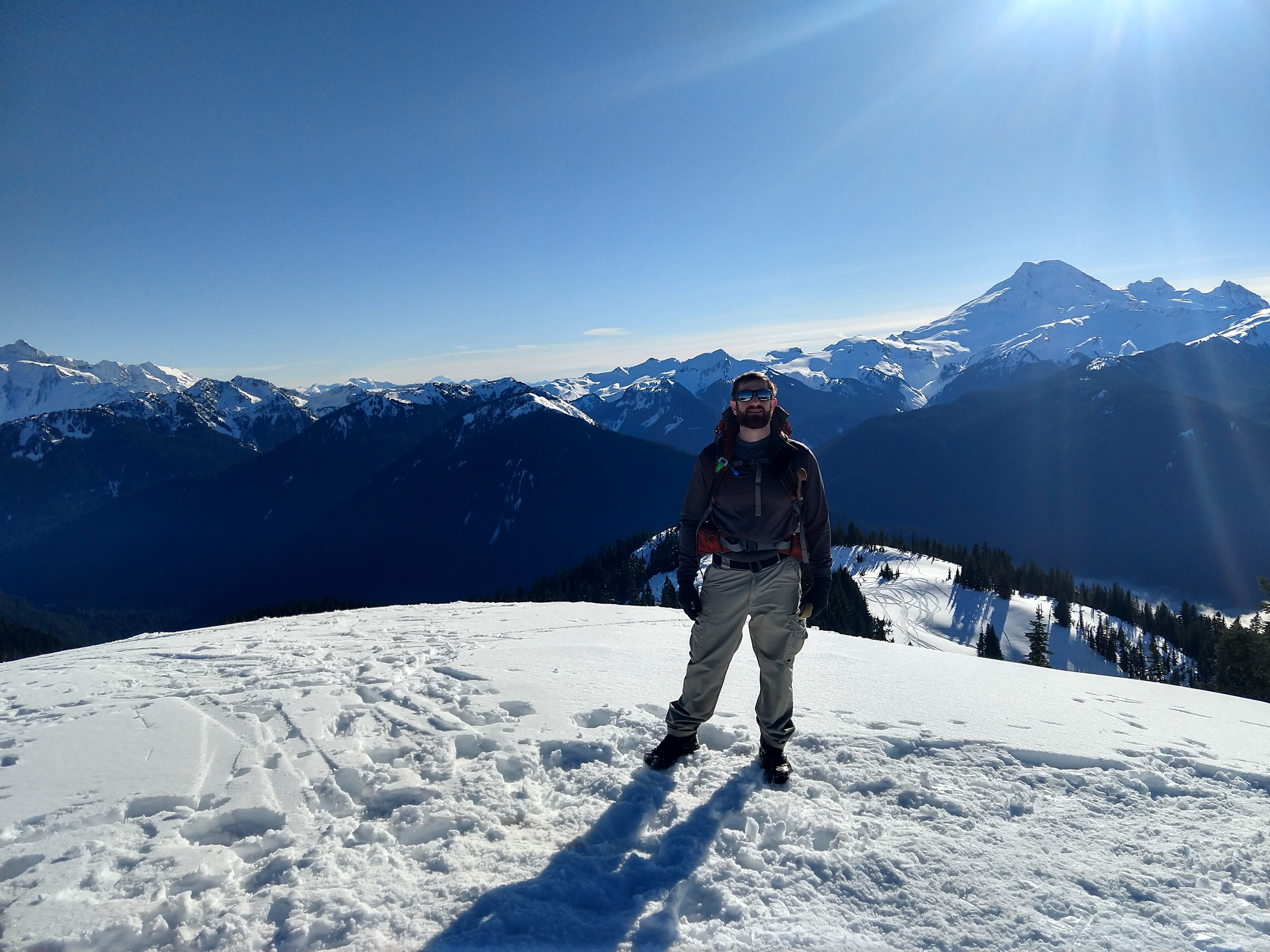
Excelsior Peak
Once we got to the Peak, we had pretty solid 360 views of the entire region. North was Canada and Canyon Ridge (US side). To the West was Bearpaw Mountain and Church Mountain, along with the ridge connecting Excelsior Peak to Church Mountain. To the South was Skyline Divide, Ptarmigan Ridge and Mount Baker. To the East was Mount Shuksan, Mount Sefrit, East High Divide, Mount Larrabee and Tomyhoi Peak. All amazing views and worth the trip.
We were fortunate enough to have clear skies at the top. In some of the pictures you can see the cloud level in the valley below.
For views from Excelsior Peak and Pass in the summer check out my post from July 2018 here. We decided to just take a good long break here to eat some food and take in all the views. Pictures below of the views from the summit of the hike. As you can see, the views stretch well beyond what I could see from my previous trip (August 2018 Goat Mountain Trip).
View West from the Peak View SW from the Peak View South from the Peak View SE from the Peak View East from the Peak View East/SE from the Peak View NorthEast from the Peak View North/NE from the Peak View North from the Peak View North/NW from the Peak


After taking our photos and taking in the views we decided to start our down hike to get through the avalanche zone. While we were up top the lady from the Pass made it up to the Peak as well. We chatted briefly about our plan to get through the zone soon. She had decided to take the same route back as well.
Peak to Bottom of Avalanche Zone. 3hr 30min (28min). 2873 cal (381 cal difference).
The way back down to the Pass and subsequently through the avalanche zone went pretty quickly since we weren’t struggling with the uphill aspect as we did earlier. We definitely made great time. As we worked our way through the avalanche zone, we did keep our separation and checked where we were along the way to ensure we both made it through without issue. After I had it through I noticed the lady making her way down from the Pass so we decided to wait and watch her get through the zone just in case anything were to happen.
This is good regardless of whether someone is with your party or not because you could be the first responder in the event something bad happens. In the snow like this it would be important to try to keep track of where someone might be in the event of an avalanche so you could potentially start the search and recovery process. Make sure you yourself in a good position as well so you aren’t contributing the search and recovery process from the victim side of things.
Looking Back at someone crossing the Avalanche Zone

Bottom of Avalanche Zone to Trailhead. 5hr 1min (1hr 31min). 3818 cal (945 cal difference).
Once the lady made it to where we were waiting we chatted briefly then took off down the trail. We also used the time to get some calories down to give us some energy on the down hike.
After we started down the trail, the distance and time seemed to pass pretty quickly, in part because we were gliding down in the snow. What took us over an hour to do on our way up took maybe 45mintues on the way down. We kept our microspikes on until about the man-made stairs rather than where we put them on just slightly higher. No issues either way though.
As we continued down past the stairs, the mist started to become more noticeable, as well as the musty smell from the surrounding decay. The temperature also felt a little bit cooler as well. The rest of the way back to the parking lot went really quick. Pretty soon we were back at the parking area and ready for some pizza at Chair 9 on the way back home. Another successful day and great views.
Trip Metrics
- Total Mileage: ~9.0 miles
- Total Elevation: ~3640ft
- Start Time: ~0957 Sunday 27 January 2019
- Finish Time: ~1458
- Est Calories: 3818
– – – – – – – – – – – – – – – – – – – – – – – –

