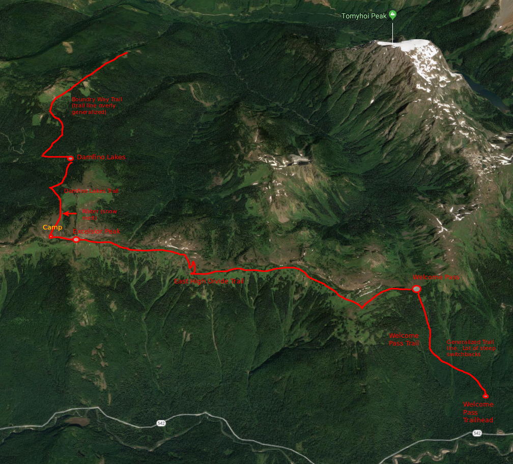
Where: Mt Baker-Snoqualmie National Forest and Mt Baker Wilderness
Where, Bounding Box (bbox): (-121.804943 , 48.901216, -121.705922, 48.991047)
What: Hiking (non-technical), Camping
When: 21-22 July 2018 (1 night, 2 days)
Who: 1 person

Washington Trail Association Links:
- High Divide Trail, (630) via Welcome Pass Trail
- Damfino Lakes Trail, 625
- Boundary Way Trail, 688
Appropriate Maps:
- National Geographic Maps:
- North Cascades National Park #223
- (bad mileage posted/referenced. Reason: over stated distances)
- Mt Baker, Boulder River Wilderness Area, Mt Baker-Snoqualmie National Forest #826
- North Cascades National Park #223
- Green Trails Map:
- **Mt Baker Wilderness, Map 13SX**
- (this is the best map for this hike and area)
- **Mt Baker Wilderness, Map 13SX**
|

Initial Route Planned
Day1: 13.8 miles:
- High Divide Trail via Welcome Pass to Excelsior Peak (7 miles)
- Excelsior Peak to Damfino Lakes (2.2 miles).,
- Damfino Lakes to Boundary Way trail, round trip (4.6 miles). Camp @ Damfino Lakes
- Modified: Returned back to Excelsior Peak for camp (1.9 miles)
- Updated mileage 15.7
Day 2: 9.2 miles:
Damfino lakes trail to Excelsior Peak (1.9 miles)- East High Divide Trail to Welcome Pass/Trailhead (7.3)
- Updated mileage 7.3
Total Mileage: ~23.0 miles
Total Elevation Gain: ~6358ft
Overall Difficulty:
Strenuous but moderate difficulty to complete the entire trip. The hike up from the Welcome Pass Trailhead to the Pass was quite strenuous, especially with a heavier pack. This hike could be much easier with a light day-pack.
– – – – – – – – – – – – – – – – – – – – – – – –
Getting to the Trailhead:
From Bellingham, take 542 north to the Glacier Public Service Center (10091 Mt Baker Hwy, Deming, WA 98244). Glacier, the town just before the Service Center is probably one of the last areas you will get cell phone service as you continue east. Then proceed about 12.2 miles (~17min) from the Ranger Station east. The Forest Road is not clearly marked, but will be on your left as you drive east. It is labeled Rd 3060 on the maps listed above. The trailhead is about 1.5 miles along the narrow, deep pothole filled unimproved road. The road will deadend at the trailhead area. Parking is very limited (about 10-12 vehicles max, if folks park smartly)
*If you get to the WADOT Station (prominent facility to your left), then you have gone too far. Turn around and drive east just a little bit and it will be the first road on your right.
Day 1:
Pack Weight Start: Did Not Measure, est 30-40lbs


Welcome Pass Trailhead to Welcome Pass. 2hr 08 min. 1880 cal.
This was a gruesome start to the weekend hike. The only way to get the top of the pass is to hike every bit of the 2740 vertical feet in elevation difference over the course of about 2.3 miles. The initial beginning is somewhat gradual along an old logging road (at least it looked like it could be) and steady but then the good stuff. Switchback after switchback, after another steep switchback and then another. I don’t really count switchbacks, nor do I feel a need to keep track of that sort of thing just yet, but there is a lot of them. You will get to the top when you get there.
This would have been a moderately difficult hike, but certainly worthwhile, with even a daypack. You will surely be stopping plenty along the way to catch your breath and drink water, unless you do this sort of thing daily in which case it will be a breeze to the top. You will cross over a couple streams on your way up, but nothing major. Depending on the season, it could be flowing or trickling. The trail up is mostly through thick forest and vegetation with the occasional glimpse at Mt Shuksan, Slate Mountain (just north of Mt Baker), Mt Hermann (just north of Mt Baker) or even Mt Baker herself. It was somewhat cloudy throughout the day so some of the views weren’t as clear. Oh well, it’s not always about the view, though they certainly don’t hurt. Once you get to Welcome Pass, you’ll notice a trail post with the various directions for this trail and that. Here you will have a decent view looking north toward Tomyhoi Peak, lots of unnamed peaks (at least on my maps) and if it’s clear enough, you can even some of the peaks and ridges on the Canadian side of the border.

Welcome Pass Trail Sign Northern View From Welcome Pass Northeastern Hillside at Welcome Pass


Just when you thought you might be done climbing you’ll leave the pass, heading generally west along the trail, to climb another 330ft. In comparison to the last stretch, this is a walk in the park. After about 0.9 miles, you’ll come to a somewhat flatter area with a great panoramic view from Mt Baker to the south, Church Mountain to the west, and due east is Goat Mountain. This was a great place to stop and take in the views. I definitely stopped here for about an 30-40min to catch my breath, eat some food, take, pictures and appreciate the opportunity.


Once break time was over, I saddled up and proceeded along the East High Divide Trail, going westward. This portion is about 3.8miles. The traverse gains and losses elevation along the way until you get to Excelsior Peak, but nothing worry about. You will stroll through some steep-ish hillsides, followed by an open slow sloped saddle, then more steep-ish hillside trail. You’ll maybe gain about 430ft in elevation from the ups and downs, maybe more, maybe less. I dont keep track of this either except for glancing at the general changes on the map so I know what to generally expect along the way. There was some snow I needed to walk through along the traverse, but nothing unmanageable. Snow this late in the season is always nice (especially coming from Virginia where snow is pretty much nonexistent past March-ish), but can be an annoyance when its on the trail and the warmth from the ground melts the underside of the snow-pack so you tend to post-hole quite a bit. After you finish meandering along the traverse you get to the east side of Excelsior Peak, you can either go down and around or straight up to the Peak. I chose the peak (why not!?) as it was a pretty free and clear peak so the prospect of some views, and cool breeze, was desired. The peak provided a great panoramic overview of the entire area as the scattered clouds had lifted in some areas and obscured others. Definitely 360 views at the peak though, so no complaints. I made a note in my head at the time as I glanced down at the Excelsior Pass area, that this might be a great place to camp for the night with a full view of the night sky, which is one of the many reasons I love to go hiking and camping in remote areas. Pretty much unadulterated views, free from the bombardment of light pollution and man-made structures. I stayed at the peak for almost 30-40min to eat some, hydrate more, take pictures and stare out at the surrounding landscape.

Mt Baker hiding in the clouds Mt Shuksan Church and Bearpaw Mountains


Excelsior Peak to Damfino Lakes, 7 hr 15min (2hr), 5361 cal (1111 difference)
Once break time was over, I proceeded off the peak and down to the Excelsior Pass area where I would begin the descent to Damfino Lakes. As I got down to the stream, I figured this would be a great place to refill my water reservoir, 3L Platypus Hydration System. I assessed the water source to be sufficient, coming mostly from the snow melt in the draw coming down between Excelsior Peak and Excelsior Pass and non-stagnant. I’ll talk more about water sources and evaluation in a separate post. I did bring my Katadyn Hiker Pro Water Microfilter so pumping directly into my water reservoir was easy going. The water was quite chilled and refreshing now that the heat was starting to pick-up going into the early afternoon. I noticed I only took in about 1.5-2L of water since starting out, so knew I needed to keep on top of it and drink more over the next 6+ hrs. You certainly don’t want to drink too much (issues with flushing out too many electrolytes), but you also don’t want to dehydrate yourself on any hike. Nothing to prove by doing that and you’ll only damage your body.
On the trail again. I had to cross the stream a little ways after filling up my water. This seemed pretty easy at first but the amount of snow between where I needed to cross and not knowing where exactly the stream below me was, posed a minor glitch. I didn’t want to post-hole and twist an ankle or get my feet soaked in the cold water. By the looks of it, not many people had taken this trail for a little while as the remnants of foot tracks was minimal and melted.
Damfino Lakes to Boundary Way, 8hr 35min (1hr 20min), 6270 cal (909 difference)
By this time, the heat had somewhat set in. Since I was at a slightly lower elevation by the time I got to Damfino Lakes the heat was more noticeable, especially with little to no breeze. The lakes were pretty stagnant and you could see the insects flying about in clouds. It was best not to stop for too long otherwise the mosquitoes would descend in on your position to suck the life out of you. This was a decent area, but it lacked the open skyview I was somewhat hoping for so I began thinking about the timeline before sunset would arrive in order to make it back to the Excelsior Pass area.
I set out on my original trip to to make it all the way to Boundary Way so I could see the view into Canada and its mountains and ridgelines along the US-Canadian Border. I decided to push on via the Boundary Way Trail. Why not? Every mile after getting to the end of the Boundary Way Trail will be less miles I would have to do on Sunday. I carried everything with me so if I got into a bind, exhaustion or ambient light, I could just pitch camp at the Lakes even if they weren’t ideal. This was going to be a 4.6mile round trip, which based on my previous segments today, would take at least 2-3hrs. From Damfino Lakes, its about 920ft elevation gain.
Damfino Lakes Damfino Lakes


The trail segment that splits off from Damfino Lakes Trail goes north to connect to the split between Boundary Way Tr and Canyon Ridge Trail, but it was little hard to find right away because it looks like a tree had fall where the trail would start. After seeing the sign that the trail split was there, I just walked north a little and the trail became readily accessible and visible again. This trail segment wasn’t anything to write about, just a go between, though the shade created by the hillside was a good feature at that time of day.
Once I got up to the trail split between Canyon Ridge and Boundary Way, I took the right-hand right. There is a clearly marked sign so you won’t have to go it alone if you don’t have a map with you. As you round the side of the hill, you’ll be able to see Cowap Peak to your north. The trail up the mountain side gets a little sketchy because it looks like there has been some washout or an avalanche that has removed where the trail should be. Scurry past the couple of instances of this. It’s not like you are going to fall off the mountain, but you might take a little beating if you slip and skid down to the vegetation just below the wary sections. Once your past those parts, the rest is rather easy coasting, slightly uphill.
As soon as you get to the ridge top, you’ll gaze north into Canada. You can’t miss it as the peak you’ve seen all day becomes very apparent. At this distance you can see the ripples of layers in the rock across the southern face of Mt McGuire. It was a little hazy but I could still make out the snow covered mountains in the distances, which looked like they were just north of Hemlock Valley (had to look it up on Google Maps after the trip). On a more clear day, I’m certain this would be an excellent place to come for the views.
As I traversed down the ridge line toward the end of the trail, I made a mental note that this area would be another great camping area with a full view of the night sky with a more northward view. Once I was content with my trip along the ridgeline I proceeded back up to where the trail goes back down the side of the mountain.
Before going down, I stopped and took my pack off and sat down to stretch, hydrate, and eat some food while I took in the view. The angle of the sun at this point helps to show some of the features on Mt McGuire and some of the other surrounding ridges on the Canadian side. You could easily see where a what looked like a landslide had occurred on one of the southward faces. You could also see the border region, where what looks like a 30-50ft clearing in the middle of nowhere forest all along the border.


Boundary Way to Damfino Lakes, 9hr 04min (0hr 30min), 6729 cal (459 difference)
As I wrapped up the break period, I assessed my water levels and determined I would be good to make it back to where I had filled up before just below the Excelsior Pass area. I checked the time and also determined that I would easily make it back to the Pass before sunset.
The reverse course back to Damfino Lakes wasn’t any different from the way up but you did get a good view of some part of Canyon Ridge, but not much. The segment back to Damfino Lakes went by rather faster than I was expecting, though I could feel the acks in my knees now. It was starting to cool off a little more at the lakes but still stagnation in the air. Time to keep moving. Still plenty of day light with maybe 1-1.5hr back to the water refill area I had set in my mind.
Damfino Lakes to Excelsior Lower, 10hr 13min (1hr 09min), 7622 cal (893 difference)
The hike back was little uneventful. By the way still not another person encountered. This day had been pretty much absent of people outside the ones I could see in the Excelsior Pass area while I was on top of Excelsior Peak. Very strange as I would have almost anticipated seeing someone during the day, but no. This though also made me a little more cautious as I left the Damfino lakes area since I was getting a little tired and sore from the pack all day. I knew I needed to keep hydrated and make a few extra stops on this segment to stretch a little because I could feel some of the tightness in my leg muscles, especially after passing 13.8mile mark at the lakes. You do need to listen to you body and know your limits. Everyone is different but we all have our limits.
As I continued going up in elevation from the lakes, I really started thinking about the events of the night. I was thinking about getting water and food. Based on my past experiences, I knew it would probably be better to eat dinner where I was going to fill up my water so I wouldn’t have to worry about all that once I got to where I was going to camp for the night. I knew I was quite calorie deficient from the days work in comparison to the amount of calories I was intaking throughout the day. I had brought two Backpacker’s Pantry meals with me on this trip, partly to see if they were good, but I also brought them because they were the 2 highest calories meals that I saw at REI the day I got them. Eating where I would fill up water would also make more sense since I had to boil water for my Pad Thai meal.
I was thinking I would get to the water source, start the MSR WhisperLite stove to get the water started while I began to fill up my water reservoirs. I had brought 2 reservoirs because I wanted to have a full loadout of water in the morning as well as water to make my coffee and breakfast in the morning, as well as spare water for the night to continue the hydration process. After all this logistics and food thinking, I had gotten to the water source. You can accomplish a lot of thinking on the trail when no one is around. Time seems to pass quicker in these conditions, at least it seems like it. After I got everything unpacked and setup, stove heating the water, water reservoirs empty and ready with my water filter. I even put my can of beer in the snow to start cooling off so I could enjoy it after setting up camp in a little bit.


Excelsior Lower to Excelsior Pass. 11hr 30min (1hr 17min), 8400 cal (778 difference)
This entire evolution, as well as eating and relaxing, took about an hour. I spent a lot of the relaxing time reflecting back on the day, where I had started, the mileage, the sights, the trail thinking sessions all day long. The much deserved break was well worth it as I could see Excelsior Peak and Pass so it was maybe 20mins away from where I was there wasn’t a sense to rush. The sun was starting its setting ritual, but not below the horizon yet. As the stove cooled off, I packed everything away and set out to finish the final ascent for the day. This day already had a lot of elevation gain, so what is the next 320-360ft vertical distance anyway. Up and over on to the Pass.
My estimate of about 20mins was pretty close. As soon as I found a relatively flat patch of real estate to put my pack down I did. The day of hiking was done and it was time to set up my sleeping area. It was close to sunset so I move with a little more effort to get everything done in time to focus on the sunsetting process. To my surprise there was another tent just east of where I had put up my camping area. I eventually I would meet the lady with here 2 dogs. Just another outdoors person coming up to camp for the night as well. After all was set up and I had changed to some warmer and dryer clothes, I had opened my beer, a Fremont Stone Squirrel Coffee Porter, as I took in the start of the sun setting process. By this time the winds where bringing down the temperature enough to cause me to throw on my down jacket.


The sunset was going to be great tonight, the changing of colors in the sky and residual scattered clouds from blue to cotton-candy pink to a mellow orange. At the same time the moon was rising right above Mt Baker to my south. The changing colors of the glaciers from white to a creamy orange on Mt Baker as the sunset fell further and further below the horizon then back to a white-ish blue from the lunar illumination and dark blue sky. Very interesting to watch.
After the completion of the sunset, I found my way into my sleeping back to settle in for the night, knowing well that I would wake up a several times throughout the night to stargaze on such a clear night opportunity. The night sky is such an amazing thing to take in. There are so many stars that are simply not visible in most places that we live in. By staring at the space your eyes really adjust and enable you to see more than an initial glance. Sometime in the middle of the night the moon was no longer in the sky so the ambient light decrease enough to make the milky way more apparent, as well as bringing out additional stars. What a great night!.

Sub-Total Mileage: ~15.7 miles
Sub-Total Elevation: ~6000ft
Start Time: ~0830
Finish Time: ~2000 (11hr 30min)
Est Calories: 8400
Day 2:
Wake up 0700
The morning went somewhat smoothly. A great night of rest, though sporadic. I could tell that my shoulders and hips were going to be sore for the hike back, but nothing that would hold me back from doing another 15miles. I started out by getting the stove going to heat up the water for coffee and breakfast. I took the morning routine a little more casually since I knew I only had about miles back to the the truck. An easy day of mostly down hill hiking. After packing up my sleeping system and gear, breakfast and coffee were ready. This morning was so much clearer out, with very little obstruction of clouds. Mt Baker was fully exposed to the south and I could see more of the snow-capped mountains to the north in Canada. A great scenery for a mountain breakfast.


After breakfast, I tidied up my area and checked for trash or anything that I, or someone else could have left, could have left. At a young age growing up in the Scouts, I learned that you should leave no trace, and to this day I try to live by that. Now that everything was good and pack ready to go, it was time to depart. 0815. Sun rising higher on the eastern horizon with clear skies with the occasional wispy clouds here and there.
To start out I went back up to Excelsior Peak to take in the clear views once again before continuing back along the East High Divide Trail.


Now on the trail again. The greenery on the mountain sides were quite bright and contained a variety of greens, yellows, whites and occasional patches of purples. Luckily most of the trail was covered by the shade of the trees on the upward slope, with long areas of open meadows. For some reason before I knew it, I had arrived back at the viewing area I took my first break at one the beginning of the traverse the morning before. It was only about 3.8 miles but felt like 2. This time, a much more beautiful view.

Welcome pass, 2hr 14min, 1600 calories
After getting to the Welcome Pass trail sign, I decided it a was a good time to take in some nutrition and more water, even though I had been drinking some along the traverse. I finally saw some people the trail, but they had dropped their packs to proceed up the hillside just northeast of the Welcome Pass area.
Break time is over! Time to saddle up and begin the steep descent down the numerous switchbacks ahead of me. One of the few things I dislike is going down hill on hikes because it’s so hard and achy on the knees, but a necessarily event in hiking. The trade off for good views, and good times. Further on the way down, I encountered a few more groups of people. More than I had seen so far this weekend if you can believe it. After I past the last group, the rest of the way was just more knee pounding down the mountain. This all past by much faster than the hike up this hill though so there is a silver lining to that aspect of it.
Trailhead Parking. 3hr 43min, 2432 cal (2370 difference)
Finally, my arrival at the truck! A good end to a great weekend of hiking. Time to unpack parts of my pack and change into some different clothes for the drive back. After getting everything settled and situated, dirty clothes and stinky shoes in the bed of the truck, it was time to depart the trailhead. Time for some pizza to offset the major calorie deficiency at the Chair 9 in Glacier before heading back home!
– – – – – – – – – – – – – – – – – – – – – – – –
Sub-Total Mileage: ~7.1 miles
Sub-Total Elevation: ~360ft
Start Time: ~0830
Finish Time: ~11:42 (3hr 42min)
Est Calories: 2432
– – – – – – – – – – – – – – – – – – – – – – – –

