Summary
Saturday hike from Deep Creek Trailhead to the Rock Creek Trailhead in the Medicine Bow National Forest in Wyoming. This is a difficult, non-technical hike, although difficulty is highly dependent on mileage. Hiking one-way is of moderate difficulty due to the trail condition and elevation again if going from Rock Creek to Deep Creek. The views along the trail area very localized to the valley being hiked down. The sound of rush water in the creek below and beside adds quite a bit of white noise, which was quite peaceful. The roughly 23.6 mile round-trip took about 9hrs 40min.
(All pictures are clickable for larger views.)
Route Overview
Expand for more details

General Route General Elevation Profile(return trip)


In the above general route outline, the yellow was roughly the route. The trail is pretty clearly defined the entire way, although there are some overgrown areas in the lower half (near Rock Creek Trailhead). The elevation profile provided depicts the return trip from the turnaround point (Rock Creek Trailhead) back to the parking area at Deep Creek Trailhead.
Other Links:
- Hiking Wyoming’s Medicine Bow National Forest
Appropriate Maps:
There are some resources for maps. I relied on the “Hiking Wyoming’s Medicine Bow National Forest” book by Marc Smith. Amazon Referral Link
- Trail Map
- Hiking Project
Overall Difficulty:
Moderate to difficult hike. The difficulty is highly dependent on mileage. Hiking one-way is of moderate difficulty due to the trail condition and elevation gain if going from Rock Creek to Deep Creek (uphill). If you hike from Deep Creek to Rock Creek the difficulty is an easier moderate hike since its predominantly downhill the entire way.
Gear Load-out:
Expand for more details
- Gregory Zulu 40L
- 3L Hydration Reservoir
- 2.5L Hydration Bladder Reserve (for added hiking weight)
- First Aid Kit
- Compass
- Map
- 2x pair extra socks
- Food
- Rain Jacket
- Light Down Jacket
- Light-weight warming layer
- Gloves
Getting to the Trailhead:
Expand for more details
From the Medicine Bow-Routt National Forest Center on the west side of Laramie, WY, drive east along WY-130W/Snowy Range Rd for about 31.5 miles. Turn right onto Forest Road 101/Sand Lake Rd. Continue for about 17.3miles. The parking area will be on your left (pictured below).
The parking area at the trailhead is large, with room for RVs and horse trailers.

Google Maps Directions:
From the Medicine Bow-Routt National Forest Center on the west side of Laramie, WY to the Deep Creek Trailhead via WY-130 (click here) or via I-80 (click here).
Vehicle Clearance:
The road is paved the whole way with no issues needing high clearance.
Permits:
America the Beautiful National Parks/Forest is valid.
Restrooms:
There is a restroom structure at the Deep Creek Trailhead parking area.
Day Trip:
Pack Weight Start: Did Not Measure, est 25lbs.
I arrived at the Deep Creek Trailhead parking area around 10:30AM. The weather was partly cloudy in the upper 60s in the parking area. Throughout the rest of the hike, the temperature would be more on the decline, which was highly desirable.
Trailhead to Bridge Crossing. 2hr 35min
Starting out at the Deep Creek Trailhead, there was one other family group but pretty empty for being a Saturday. The initial portion goes through more meadow type areas, but that doesn’t last long. Once you get into the trees, it pretty much stays that way for the remainder of the hike.
Over the first 4-5miles there are markers along the trail but they are very scarce after the sign for Sheep Lake/Crater Lake.
3 mile marker Trail split to Crater Lake


Eventually you’ll come to another split in the trail. Keep right on the trail that goes down. Pretty soon you’ll start to get some views of the draw and valley as you make your way down. Watch out for small portions of the trail that appear to have washed out or erodes. One of the pictures in the block below shows one of the spots. Its not difficult but if you don’t have your wits about you, then you could find yourself slipping down the steep hillside.
Keep right at the split Degraded and washed out trail Just before the rain


About an hour and 40ininutes into the hike and I started encountering rain. For the remainder of the hike there was on and off rain. By the time I reached the bridge in the final picture of the next block, it was staying pretty consistent. The brief moments when the sun came out, I tried to take advantage to take pictures.


Just across the bridge I took a short break to take in some food. The bridge is roughly the halfway point between the two trailheads.
Bridge Crossing to Rock Creek TH. 4hr 20min (1hr 55min)
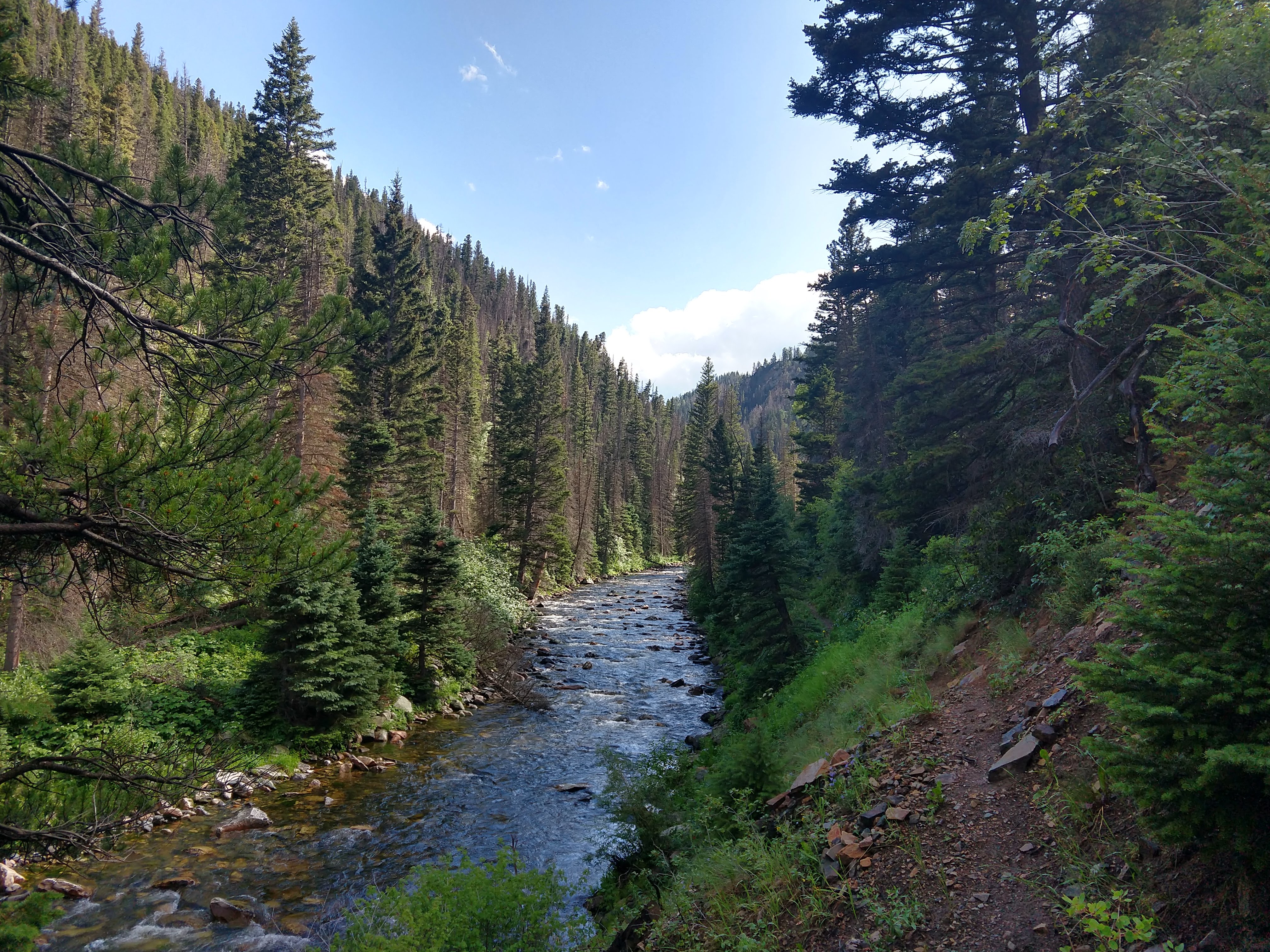
During the segment, the rain was generally pretty light until the last few miles. The trail runs more right along the creek the rest of the way. The trail is also pretty rocky in areas and they quickly becomes overgrown with the vegetation along the trail.
Last shot before the rain poured down to the trailhead


As I arrived at the Rock Creek Trailhead, the sun came out and it stopped raining, which was nice because I could layout my wet clothes and eat without having to stand in the rain. My boots and my clothes where completely soaked and there was really no escaping it. There was some hope for my clothes drying out, but my boots were beyond the point of drying out for the remainder of the hike. I also used the time to work on a summer sausage and crackers to begin recouping some carbs, proteins, fats and salts for the long haul back. I took about 30mintues to rest, eat and prepare for the next leg of the hike.
The return trip was a little daunting standing at the trailhead since I knew the whole way would be uphill the entire way in my soaked clothes and boots, but knew it wasn’t going to be impossible since I had hiked the mileage plenty of times before. There is nothing wrong with a little discomfort and misery to work on your mental endurance. It helps build character as well as helps you develop or refine mental and physical toughness.
Soaked boots Sun drying my clothes and gear Trailhead Board Parking Area


Rock Creek TH to Deep Creek TH. 9hr 41min (4hr 52min)
At the Rock Creek Trailhead, I had estimated that it would take about an hour longer than it took to get here since it would be uphill the rest of the way. Generally speaking in my hiking experiences, I tend to shave off about 15 minutes per hour hiking downhill, and it took 4hr 20min hiking downhill. So I estimated it would take about 5hr 30min to get back.
I was lucky that the rain held up for about the first hour back on the trail where the skies were somewhat clear and blue. This opportunity allowed for much better enjoyable views.


Towards the end of the hike, the rain stopped. As I got closer to the Deep Creek Trailhead the sunset cast beautiful colors against the scattered clouds above and greenery seems very vibrant, as you can see in the pictures below.


Just before I got to the very end, I saw 2 moose grazing in the meadows. This was a major change from the entire trip where I hadn’t seen any animals.


After getting back to the Deep Creek Trailhead, I was little shocked that it took me roughly the same time each way. I certainly was feeling exhausted and ready to take off my boots and get into dry clothes.
Trip Metrics
- Total Mileage: ~23.6 miles
- Total Elevation: ~2931 ft
- Start Time: ~10:51AM Saturday 27 July 2019
- Finish Time: ~8:32PM
- Total Time: 9hr 41min
- Total Calories: 6300


Love the photos and hearing about your moose sighting.