I got up around 6:40AM to catch the sunrise over breakfast. By this point, my morning routine was pretty efficient. Packing up camp and eating breakfast. Too bad it was my last night in the backcountry. During breakfast, I went back to the same spot I found the night before knowing that I would be able to view the valley below. While eating breakfast on the rocks, a family of deer made their way up past me, probably 20-30ft away. I kept quiet so as not to disturb their morning. It was a good morning already.
As the sun rose, the air was pretty clear so I could see the mountain ranges in the distance looking eastward (as seen in one of the pictures).


Around 7:50 AM, I departed camp after policing up the area. If you make it a habit you’ll do it every time without forgetting and it really doesn’t take much time. You reduce the chances of leaving behind any trash or gear, both of which should be carried out regardless. LEAVE NO TRACE.
Instead of going up to Holly Lake again, I decided to get back on the main trail where I branched off the day before. This would ensure I got to see the area from a different perspective and experience more of the area besides Holly Lake.

General Hiking Route Elevation Profile


Up to Paintbrush Divide

Once I got back to the main Paintbrush Canyon trail, I continued along the rocky trail. According to the sign, Paintbrush Divide was 2.2 miles. I figured that would be at least an hours hike, plus time for elevation gain.


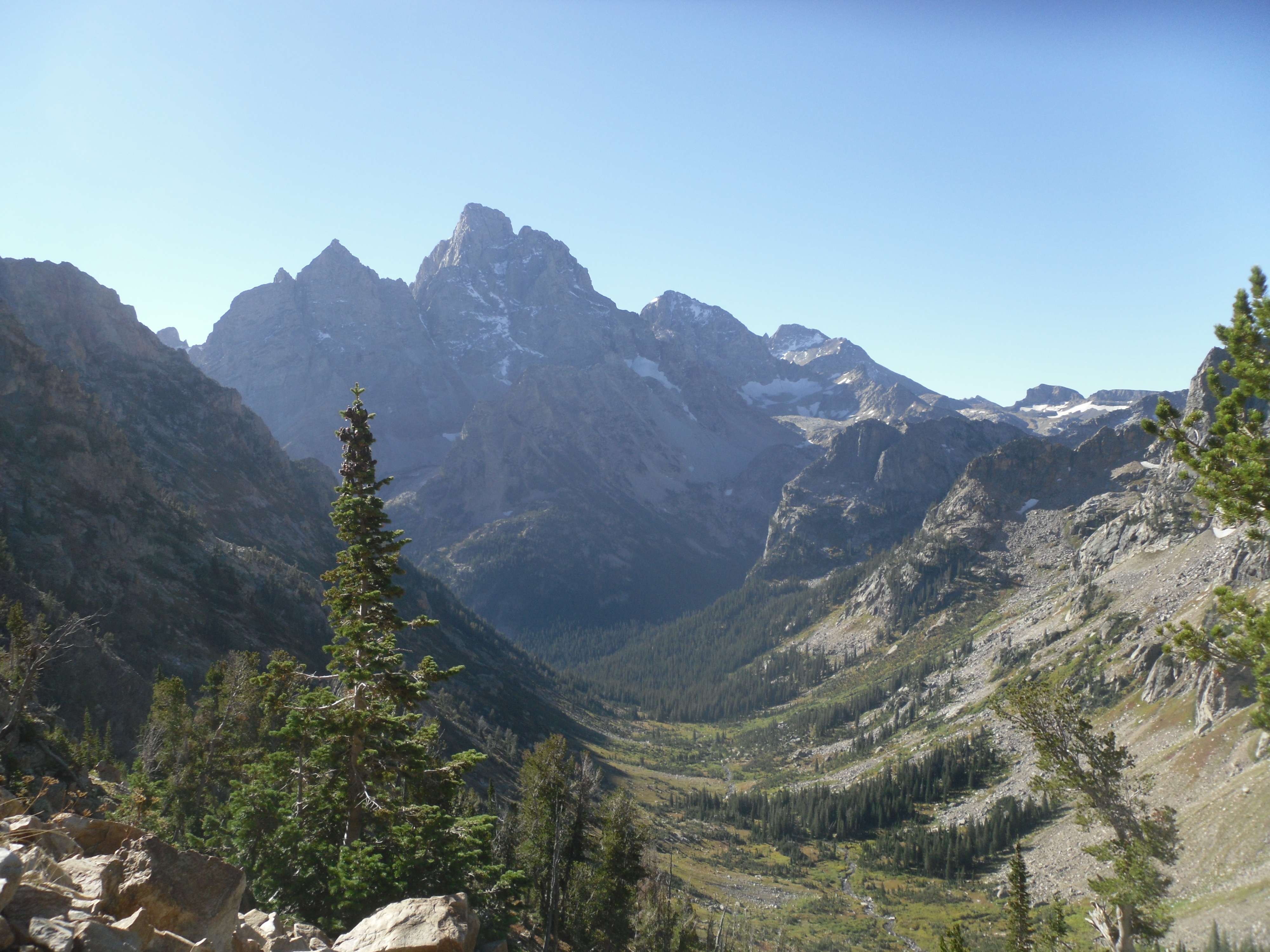
As I gained elevation from where I was camped, I got some good views of the southern canyon ridges and peaks, a lot of which still had snow (most are designated as glaciers).


Looking back down Paintbrush Canyon toward Jackson Lake. No one was on the trails yet so it was all pretty quite besides the morning chirping of the birds.


As I continued up to the divide, I got a little more out of breathe here and there as I was trying to maintain my pace. I just needed to slow my pace a little and work on controlling my breathing. There was a patch of iced over snow I had to cross. I was quite careful about that as well because it was a steep long drop if I wasn’t. It was a good thing that there were foot steps from the days before, likely made during a warmer time of the day when the snow was soft.
View south from Paintbrush Divide Thor Peak, Mount Moran


The last quarter mile was very windy. The closer I got to the divide, the more windy it was as the wind crossed the divide and made its way down the canyon. I would guess the gusts ranged in the 10-20mph range. I got to the Paintbrush Divide sign around 9:15 AM. About 1hr and 25 minutes. My time estimate was pretty good.
The views from Paintbrush Divide were once again amazing. You had a great view down Paintbrush Canyon, the range to the north of Mount Woodring (Thor Peak Mount Moran), and the ridgelines west/northwest.


Down to Lake Solitude

The rest of the trip from the Divide would predominantly be downhill, as seen in the elevation profile above and the remaining pictures below. From Paintbrush Divide, its about 2.4 miles down to Lake Solitude. Once you crest the ridgeline you see Lake Solitude the entire way down to it. Along this segment is where I started seeing groups of people make their way up to the Divide. They likely camped in the North Fork camping area.
The trail was rocky the whole way down to the lake. In the pictures below you can see the view of the North Fork of Cascade Canyon, the region to the west and the area north, where Maidenform Peak is as part of Leigh Canyon. There isn’t any clear trails on the map that take you north into Leigh Canyon.
North Fork of Cascade Canyon Ridgeline above North Fork to the West Maidenform Peak in the background


Once I crested into the North Fork portion of the Cascade Canyon, the wind gusts dropped off significantly. Since it was still morning, the temperature was pretty cool. I had to wear my silk glove liners and work gloves to keep my hands warm. Its not really a good idea to keep your hands in your pockets while hiking for a few reasons (not going into it right now). I will also do a write up about my glove layering system in the near future.
Once I got to Lake Solitude, I dropped my pack and grabbed my water filter. Along the way down, I had finished all my water in my reservoir. The water was very cold and quite clear. There was a couple of folks that had jumped in near by and I could tell they were quite cold when they got out. After filling up my water, I sat on the rocks, warming up and eating some food. Its important to eat along the way to maintain your energy levels throughout, especially on a longer distance day like today. Already, I had hiked just under 5 miles and still had about 9-10 more to go.


I hung out at the lake for about 30 minutes. It was quite a location. I would definitely hike here again. It was really quiet peaceful in the morning like it was. With the sun high above you could really see the details of the surrounding rock faces.
North Fork
Time for the next segment down the North Fork of Cascade Canyon. This part would be about 2.7 miles to the junction with the main Cascade Canyon trail and the South Fork trail section. As you descend in the canyon away from Lake Solitude, you become surrounded by huckleberry shrubs and scattered bunches of trees. There are also lots of little water falls as the overflow water from Lake Solitude makes it way down the canyon, eventually ending up in Jenny Lake.
Greens, reds, yellows cover the canyon floor Looking back to the North I am guessing this is The Wigwams Grand Teton and Mount Owen North Fork of Cascade Canyon


The further down the canyon, the more areas of trees. There were a few mini boulder fields you traverse through but a clear easily hikeable trail. There were lots of areas of the trail where you couldn’t see around the various bends so I made sure to ring my mini-cattle bell (much louder and distinguishable from a cheap bear bell) in an effort to mitigate a bear encounter or at least not startle it. The pictures below show the progress down the canyon toward the junction. The views along the entire path were spectacular, though there was a bit of a haze to the air looking toward Grand Teton and the surrounding peaks.


Cascade Canyon


A little over an hour after departing Lake Solitude, I had arrived at the junction. At the junction itself, there isnt much to see because of the surrounding trees in that particular area. There are gaps in some areas where you can see bits and pieces, but nothing riveting enough to stop for a break. There were also a lot of people at the junction and would be the rest of the way.
Below are some of the views near the junction
Looking south from the junction area Unnamed Peak N of the junction on my map. It tops out at 11012ft Looking east down Cascade Canyon Unnamed Peak W/SW of the junction on my map. It tops out at 10635ft


The further down Cascade Canyon, the look backs (westward views) gave you a better perspective and vantage of the canyon’s junction and surrounding area. Along the trail, I came across some people that were from the Maryland area, relatively close to where I was from. We talked for a bit while they were taking a break. They ended up walking back down the Canyon with me so we chatted most of the way. Small world!


Before going too far down the canyon, I thought it would be good to top off my water since I could tell I was getting low. There was a excellent area along one of the creek banks with semi-fast moving water. It didn’t take too long but it was a good call in hindsight because this was one of the easy accessible spots the rest of the way and the temperature was rising as we were past noon with the sun high above and no clouds.
About 2/3 of the way down the canyon there was a moose and her calf taking a break on the bank of the creek. They were far enough away that people hung out on the trail without being worried about any issues with the moose. While I was observing, I did see a third moose pop out of the vegetation along the bank, but it stayed pretty hidden. This was definitely a great sight as I hadn’t seen much big wildlife the whole trips, besides deer.
Mother Moose and her calf


Back to Leigh Lake Trailhead
I arrived at the trail junction at Jenny Lake around 2:30PM. This is where I went my way from the folks I had been walking with most of the Cascade Canyon trail. They were heading back to the camping area at Jenny Lake and I was going back to Leigh Lake.
Along the next segment that ran along the western side of Jenny Lake, I met another couple who had just moved to the area from Alaska. They were settling into the area and out on a day hike in the Park. We chatted for quite a while. During our conversation I learned more about the Grizzly attack that happened the previous Thursday (my first day at the Park). You can read more about that incident here. After the great conversation, we we went out separate ways.
During our conversation we noticed that were was a fire off in the S/SE direction. You can see the smoke and thunderheads around that are in a couple of the pictures below looking across Jenny Lake.
View across Jenny Lake Looking back into the Cascade Canyon Smoke clouds billowing up in the far background Mount Moran View toward String Lake (southern end) and Rockchuck Peak


Further up the trail as I was getting closer to String Lake, I encountered some folks that were visiting from Virginia, one of which lived just up the road from where I lived the year before. Throughout the entire trip, I seemed to encounter several people from back east.
Once I crossed the bridge over the connection between String Lake and Jenny Lake, the rest of the trail went by quite quickly than I expected. There were a bunch of families in the area hanging out along the “beach” of String Lake. Lots of folks on the trail too.
I got back to the Leigh Lake Trailhead around 4PM. 8 hours and 2 minutes since departing in the morning. That was on par with my estimates from the night before. Had I not spent time chatting with folks along the way I likely would have made it in 7hrs. That certainly was not the objective for me. Enjoying the sites and meeting people along the way makes the journey more interesting. Take your time to enjoy the moments while you can. You can certainly enhance the overall experience and memories of the trip when you engage with others to learn about them along the way. (Side note: I’ll elaborate more about Time Tracking in a separate post).
Craig Thomas Visitor Center
After wrapping up and stowing my gear away in the truck, I decided to go back to the Craig Thomas Visitor Center. When I first arrived at the park, my time at the Visitor Center was relegated to getting my permits in order and hit the trail. This time around, I was going to leisurely check out the displays and learn more about the park’s history and features.
The center is well laid out and has lots of information about the various animals in the park, the people and history of the park, some of the evolution of mountain gear. Worth checking out if you have the spare time. There is also a gift shop in the facility.

Dinner
Now that my time in the park was done for this trip, I headed back to Teton Village for some dinner and possibly a drink or two. This time I went to the Teton Thai place. I figured I would think about the timing of tomorrow and whether I would feasibly hike Table Mountain before needing to head back home. I was feeling much more exhausted and noticeably sore from today’s hike.
I ordered their Pad Thai, which was great and a good spicy. I will certainly reorder that again the next time I’m back. It came in a much larger portion than what is typical at most Thai places. I didn’t mind that because I was definitely calorie deficient from the entire trip and hungry.
While I was eating a couple from Colorado sat next to me at the bench table (outdoor seating). We talked almost the whole time. They were definitely good friendly people and I enjoyed the conversations.
Night Time
It was probably around 8:30PM when I got back to the truck. I went up to the Mangy Moose bar thinking I might grab a drink and sync up my phone on the WiFi. It seemed like a great spot to hang out. They had good music a nd a good size crowd but I eventually opted to not get a drink. I was feeling pretty wore out and had a bit of a headache. Maybe next time. So I headed back to get some sleep.
As for the next day, I would leave it up to how I was feeling in the morning. I had thought if I got up around 4AM, I might be able to accomplish the hike. I estimated it would be at least 5-6hrs round-trip. To get to Alta, WY for the Table Mountain hike would be about a 40-50min drive. It wasn’t much out of the way either. I had set in my mind that I needed to be heading home by 12-1PM since it was going to be about a 13-14hr drive. I ended up not setting an alarm and just played it by ear. If I was too tired and exhausted to get up early, then it just wasn’t meant to be.
Day 6
I got up around 6AM with the rising sun. After shuffling my gear and getting ready to depart, I decided to head back home. It had been a great trip. I got a lot of mileage on my feet. Lots of sights to take in. Lots of pictures to help me remember my entire trip (almost 1000!). I had already accomplished the majority that I had set out to do during my trip planning. I didn’t get the Table Mountain hike in, but I did get to Rendezvous Mountain, which was unexpected. I’ll call the whole trip a win.

There will be another trip to the Tetons after this experience. There is so much more to hike and see in the area.
Daily Stats
Total Miles: 14.4 miles
Total Elevation Gain: 2688ft
Total Calories Burned: 4212 calories
Total Time: 8hr 2min
Total Trip Stats
Mileage: ~42.6 miles
Elevation Gain: ~11926 ft
Calories Burned (recorded activity only): 18,696

