
Summary
Saturday morning day hike up Goat Mountain in the Mt Baker-Snoqualmie National Forest/Wilderness with a friend. This is a non-technical hike that is generally moderate to strenuous. There is substantial elevation gain over the approximate 4.5 miles to the west Goat Mountain summit area. The weather and temperature held very well for this trip in contrast to my previous overnight trip. The hike took us about 6hr 10min, which included about 1hr 20min of breaks to take in the views at key areas along the trail.
Route Overview

Generalized Route Overview Genarlized Elevation Overview


Washington Trail Association Links:
- Goat Mountain
Appropriate Maps:
- National Geographic Maps:
- Mt Baker, Boulder River Wilderness Area, Mt Baker-Snoqualmie National Forest #826
- This provided a good overview of the area/surrounding area, but would not be practical for the details of the trail.
- Mt Baker, Boulder River Wilderness Area, Mt Baker-Snoqualmie National Forest #826
- Green Trails Map:
- Mount Baker Wilderness, Map 13SX *** Best Map for the Hike ***
- This was the best map for this hike and area. There is a lot more fidelity to the trail features and switchbacks.
- Contours are much easier to see.
- Mount Baker Wilderness, Map 13SX *** Best Map for the Hike ***
|

Overall Difficulty:
Moderate to strenuous during most sections. Strenuous during the last mile of the hike to the summit.
Gear Load-out:
- Marmot day pack [Amazon Link]
- 3L Hydration Reservoir [Amazon Link]
- First Aid Kit
- Sunglasses [Amazon Link]
- Light down jacket
- Light rain jacket [Amazon Link]
- Beanie
- Light gloves
- Compass
- Map
- 1x pair extra socks
- Food
– – – – – – – – – – – – – – – – – – – – – – – – – – – – – –
Getting to the Trailhead:
From the Glacier Public Service Center, drive east along WA-542 for about 12.8 miles. When you get to the WADOT facility (on left), its about 0.3 after that on your left. The turn off is a quick left turn just before the bridge and could easily be missed if you are going too fast. The corner also makes it difficult to see oncoming traffic as you cross the road onto NF-32. If you drive over the bridge or get to Silver Fir Campground area, turn around and drive back a short distance. The bridge is the prominent feature.
Once you are on NF-32, continue to drive about 2.4 miles. You will pass the Nooksack Cirque Trail Road sign about 1.3 miles in. Continue on. The trailhead is clearly marked. Do not get confused by the unmarked road on your left(picture below). You cant miss the lower and upper parking lots and the signs that says Goat Mountain Trailhead. There is somewhat plenty of parking but it really depends on how much space people think cars need. Park smartly so others can enjoy the trail as well. At the upper parking lot, there is a maintained bathroom structure.
Vehicle Clearance:
I drove a truck with no issues. You could take a lower clearance vehicle but watch out for the deep and numerous potholes. The potholes shouldn’t be an issue to straddle or drive around them if you have a low clearance vehicle. The road is also generally wide enough in most areas for 2 way traffic. In the areas were the road is more narrow there are plenty of small pull-off areas in both directions.
Wrong Road, Continue Straight! Correct Location. Goat Mountain Trailhead Goat Mountain Trailhead, Lower Lot Parking Area


Google Maps Directions: https://www.google.com/maps/dir/Glacier+Public+Service+Center,+10091+Mt+Baker+Hwy,+Deming,+WA+98244/Goat+Mountain+Trailhead,+Glacier,+WA/
Permits:
You do need a National Parks/Forest or Northwest National Forest Pass for this area. Display appropriately as this trailhead is much more accessible and likely to be visited by the Forest Service. If you don’t bring your pass, or just don’t have one, you can get a pass at the Glacier Public Service Center on your way in.
– – – – – – – – – – – – – – – – – – – – – – – – – – – – – –
Day Trip:
Pack Weight Start: Did Not Measure, est 10lbs. No picture.
Goat Mountain Trailhead to Mt Baker Wilderness Sign. 0hr 44min. 500 cal.
Starting at 0900, the parking lot had only 1 vehicle in the lower lot and 0 vehicles in the upper lot. The weather was a brisk 34 degrees and the sky was clear. The initial part of the hike is through semi-dense forest with little to no views most of the hike up to the first overlook area (marked on map above). It was a very quiet morning. We encountered one person within the first mile of the hike. He would be the last until our decent from the summit. We were somewhat surprised due to the nice weather.
A lot of the small creeks running across the trail were dried up this time around. My previous reference was from early August, when the little creeks had plenty of water for the dog to drink from. After a series of switchbacks, we got to the Mt Bake Wilderness boundary sign. Based on my estimate from my previous trip on the trail, we were making good time and had a solid pace. Now we would be gaining the majority of elevation over the next 1.5 miles.
Mt Baker Wilderness Sign to Look Out area. 1 hr 45 min (1hr). 1214 cal (714 cal difference).
From the Mt Baker Wilderness sign, the trail begins to become less gradual in grade. Pretty soon you will be heading back and forth on some switchbacks as you gain more noticeable elevation. There is a small section higher up where some of the vegetation was still overgrown, but not as bad as my previous trip.
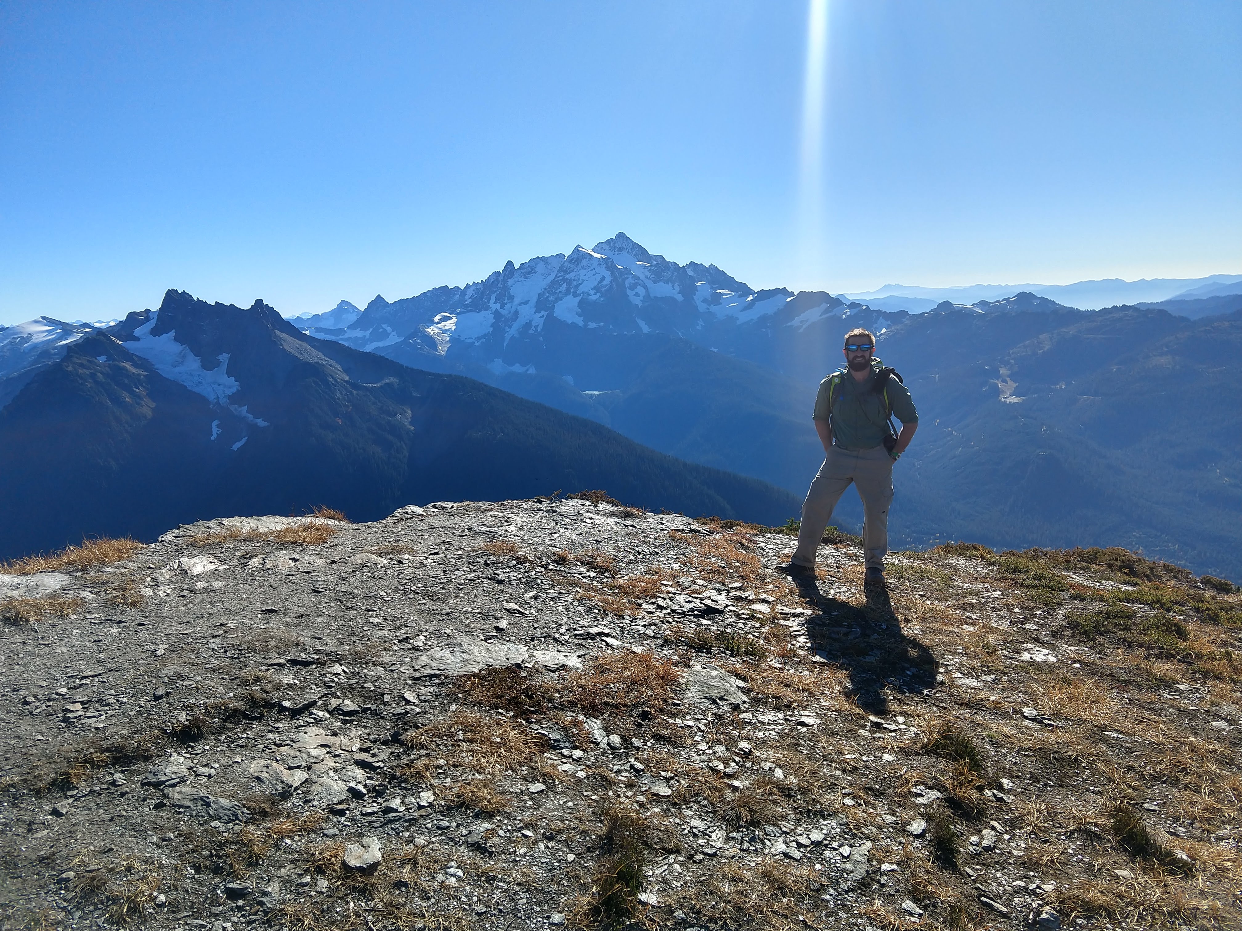
Around 1045, we arrived at the first prominent look out area. There are several areas you could take a break, away from other hikers. We ended up breaking where I had hung out previously. The foliage was much more in the fall season with the huckleberry shrubs taking on an array of colors from a radiant red to a heavy yellow. There was still plenty of greenery as is common in the pacific northwest. Most of the huckleberry shrubs had been stripped of their fruit by the animals in the area getting ready for the winter.
From our break spot you could see the recent snow accumulation on the north face of Mt Shuksan. In contrast to the last trip, the views were much more clear. There was certainly low to no humidity causing almost no haze or clouds in every direction. This was definitely turning out to be a much better trip, though camping out on the arm would have been highly desirable.
Mt Sefrit and Mt Shuksan Mt Baker behind Mt Herman and Slate Mountain Looking westward toward Church Mountain and Skyline Divide Looking eastward toward Granite Mountain and Hannegan Pass


After about 15-20 minutes, we got back on the trail. Still no sightings of other hikers. From our vantage you could see alot of the fall colors spread about the mountain side giving the landscape a wild fire affect from the reds, yellows, orange and browns with various areas set in their shades of greens.
Look Out area to Summit. 3hr 12min (1hr 30 min). 2205 cal (999 cal difference)
After a short hike from the overlook, we had arrived at the upper portion of the arm/upper look out area. This is the last relatively flat area before the section that goes straight up. At this point we were both feeling energetic and fresh. The lack of an overnight pack makes a difference in your speed and stamina.
My old campsite would have been even more ideal now since the sun would be setting lower on the horizon, making a great vantage point for both sunset and sunrise at this time of the season.
Now the part where you earn the view! As you finish a short little switchback and traverse across the lower portion of the mountain, you begin the steep ascent. This is segment will definitely let you know if you need to be working your calves, quads and hamstrings more during your conditioning routines.
Once you get to the lower shoulder of the ridgeline you begin heading east/northeast along the clearly defined trail. Along the entire ridge line you get to see the north/northwestern panoramic views. You will see Tomyhoi, Yellow Aster Butte, American Border Peak and Mount Larrabee. Since the skies were really clear, we could see a lot of the southern peaks in British Columbia, Canada. Off in the far northern distance you could see up to the range housing Mt Clarke, Recourse Peak and Viennese Peak (Google Maps reference).
After about an hour since leaving the the overlook area, we arrived at the summit area of Goat Mountain. The true West Summit is actually a little bit north (cant miss it), but it would require back tracking some, crossing the little glacier on the north side then what looks like a reasonable scramble to the peak. We decided we would do that another time. You could also look just east of our position and see East Summit of Goat Mountain.
As we passed the north facing glacier, we noticed that there was some good recent snow accumulation already.
We decided to just take a good long break here to eat some food and take in all the views. Pictures below of the views from the summit of the hike. As you can see, the views stretch well beyond what I could see from my previous trip (August 2018 Goat Mountain Trip).
When we looked down at the glacier below on the eastern side we could see a lot of animal foot traffic in the recent snow accumulation. The tracks were likely mountain goats, though we hadn’t seen any thus far.
View S/SW View West/NW/N View N/NE View NE/E View E/SE View E/SE View S/SW


Summit to Trailhead. 6hr 10min (2hr 58min). 3595 cal (1390 cal difference).
After close to an hour at the top, we decided it was time to make our way back. Below are a few of the views along the ridge before the steep descent. In a couple of the photos, I tried to capture how vivid the reds were but the pictures again don’t do it justice. You’ll have to see it for yourself in the fall time.
Looking back at the Goat Mountain Summit


This is the view at the lower part of the ridge line before you begin the descent. Here you can see a wide range from the west to the north.
View W/NW View N View N


As we made our way back down to the arm we began to encounter a couple of hikers on their way up. The photo below is the beginning of our descent down the gradual arm to the overlook. Along this segment, we began to encounter several more small hiking parties.

Once we hit the treeline again, the temperature cooled down a good bit. Since we were already worked up, the cooler temperature felt pretty good and remained comfortable all the way back to the parking area. As always, the trip down goes by much quicker. In a little over two hours, we arrived back at the trailhead. Another great hike, that is worth at least one annual visit and quite worthy of a camping outing. During this fall day, the colors of the landscape where dramatically different in several ways from my summer trip. I will try to do this hike again in the winter when the snow has fallen to provide another perspective.
Trip Metrics
- Total Mileage: ~9.0 miles
- Total Elevation: ~4300ft
- Start Time: ~0900 Saturday 20 October 2018
- Finish Time: ~1512
- Est Calories: 3595
– – – – – – – – – – – – – – – – – – – – – – – –

