On Friday morning, I proceeded to the Craig Thomas Discovery & Visitor Center to workout my backcountry permitting with the Park Rangers. The Building is open daily from 8am to 7pm and you can work with the Rangers during that time. I got to the Visitor Center around 8:30 AM and I had to wait in line for the next available Range to begin building the itinerary.
Having worked out different variations in the bar the night before helped me to understand some of the scenarios I would pursue depending on campsite availability.
Itinerary Building
Before working on the itinerary, I noticed they had a board displaying key camping areas and whether they were fully reserved or not. I anticipated doing Amphitheater Lake first, but it was all booked up for the night, so I began thinking I would do Signal Mountain since it was a shorter hike and likely better for building up for the altitude an extra day.
After consulting with the Ranger of my hiking goals for the trip and anticipated daily mileage, she helped make the whole itinerary much better, giving me all 3 nights in the backcountry at group sites. That last feature is quite handy because it meant I wouldn’t need to carry a bear canister for my food and smell-ables. She mentioned that it would likely be better this for due to the mileage I would be doing and by myself. That group site aspect was something I didn’t consider in my planning for the specific reason, I was just a solo hiker and didn’t need much space. In hindsight that worked out really well.
Total cost for the trip would be $35 for 3 backcountry camp sites. This is much better than having to stay at a fixed car pull-up campsite at $30/night.
Plan for the next 3 days
First, I would hike Signal Mountain, followed by a stay at South Landing, which is just a little south of Signal Mountain along Jackson Lake. This was a good first day since it would give me an additional day to get used to the altitude. Though the altitude didn’t seem like an issue I was concerned about after the day before, the extra day probably made the following 3 days better.
Next, I would go to Lupine Meadows to hike up to Amphitheater Lake. Instead of hiking back, making it a long day, I would camp out at Surprise Lake, which is only 0.2miles from Amphitheater Lake. This split of what would be a day hike, would position the morning to be a 5mile downhill hike, followed by equal or greater mileage in the afternoon.
Next, the last backcountry night would be at Holly Lake in the Upper Paintbrush Canyon area. From Leigh Lake Trailhead, this would only be under 7miles of hiking in the afternoon. Something I knew I could manage after a 5mile downhill hike. This also meant that I could do the whole Paintbrush Canyon-Cascade Canyon loop that I had initial hoped I could do during my trip planning.
Finally, the day after hiking up Paintbrush Canyon, I would do some uphill hiking to Paintbrush Divide in the morning, followed by downhill hiking the rest of the way back to the truck. Along the downhill hike on Monday, I would stop by Lake Solitude then proceed along North Fork Canyon to Cascade Canyon then to Jenny Lake. From Jenny Lake, it would be a relatively short hike back to the Leigh Lake Trailhead area.
Now, it was time to depart the visitor center to really begin the hiking trip. At 9:30 AM, after conveying the itinerary to my mom and discussing the communications plan for the rest of the trip while I had cell phone service at the Visitor Center, I began toward Signal Mountain.
Signal Mountain Hike

I arrived at the Signal Mountain Lodge around 10 AM. While in the parking lot, I gathered the gear I needed for the day hike and ate my breakfast.

Breakfast: Oatmeal, powdered peanut butter, cacao, cinnamon Oatmeal with chocolate milk, is much better than just water Final mixture Daypack


It is a good thing the combination for breakfast was good, because it was set to be my breakfast the rest of the trip. A definite success that I will repeat for other hikes and trips. The chocolate milk is also ultra-pasteurized so it doesn’t need to be refrigerated (until it is opened).
At 1050, I had finished my breakfast, had my gear on and was ready to start the Signal Mountain hike. After a short walk up the road from the lodge along the road, you’ll see a sign for the Signal Mountain trail.
Trail Sign Teton Park Road Initial trail view Signal Mountain Road


After you cross the main road, you’ll continue through a wooded area before crossing the road that allows cars to drive up to Signal Mountain Summit. The trail is pretty clearly marked. You will also see these signs.

Shortly after crossing the Signal Mountain Road, I cam upon the lake. The lake was pretty calm and full of water lily. As you progress up the trail you get to a fork in the trail. One way takes you on the upper ridge, while the other takes you by the ponds/lakes. Both routes intersect again. On the way to Signal Mountain in the morning, I took the ridge route.
Lake/Pond fully of water lily Fork in the trail. Ridge or Pond routes. Views from the ridge path Views from the ridge path Views from the ridge path


Throughout the trail there were lots of signs of deer tracks, as well as remnants of visiting bear throughout the huckleberry fields. I could easily and quickly see why bear are a common occurrence for run-ins along the trail because you are essentially walking right through their food sources along the majority of the trails. You could look at the branches and leaves of the huckleberry shrubs and tell that the bear in the area had already stripped shrubs clean. Still not sight of bear on my hike though. Bear spray was at the ready, especially when I couldn’t see around the various trees, shrubs and micro-terrain.
After 1hour and 24 minutes of hiking I got to the observation point. The hike seemed pretty easy overall. Now it was time for a little lunch and a lot of observation.

While I ate, I stared eastward, up and down the Jackson Hole valley. Although I was not particularly high up, it did afford some good overviews of the adjacent ridges across the valley, and “The Potholes” grassland area in the middle of the valley floor. When I got there, there were lots of people in the area taking pictures. This is likely normal since it is a drive up area.
Below are some views of the Teton Range looking South and West from the lookout area. I used the both the Nat Geo and Larson’s map during the break to properly identify the various mountains and areas. Both maps were good, though neither show the two routes of getting to Signal Mountain from the Signal Mountain Lodge. Larson’s map does depict a trail that leads from Signal Mountain and goes toward Oxbow Bend near Jackson Lake Junction (N/NW of Signal Mountain).
Grand Teton Mount Saint John/Rockchuck Peak Mount Moran


After a nice long break of almost an hour and a half, it was time to head back. On the way back, I took the Lakes route to get both perspectives. There is a sign so it is easy to choose your destiny.


Going to the Lake was a good choice. The views were peaceful and there were good shaded areas to sit and relax some. I probably stayed at the lake for about an hour then continued on toward the Signal Mountain Lodge.
Post Hike
After returning to the truck at Signal Mountain Lodge, I dropped my pack off and grabbed a Gatorade and some food. Once I changed out my shoes for my hiking sandals, I headed to the beach just behind the lodge. There were a lot more people around the area than had been in the morning. I found an empty picnic table on the beach front facing Mount Moran and the region just north of Mount Moran.

As I drank my Gatorade and had a little food, I continued my observation of the area. Once I once done, I decided to check out the inside of the Lodge. Inside the lodge they have two different gift shops, a bar and restaurant.
Now that I was kind of down being around the lodge, I headed down the road to check out the South Landing parking area. Once I got there, it was a pretty simple and basic area. A trail sign said 0.5 miles to the camping area. That’s a pretty quick walk and I still had plenty of day light left, so I decided to drive down the road a little more to get to the Mount Moran turnout to catch the views, as well as call my folks to update my status as per our communication plan. Once I was good with the view, I headed back to the South Landing parking area to begin the nightly process.
Mount Moran Info Placard Mount Moran Turnout Area


End of the Day

I packed my pack in the parking area for the overnighter as if it would be packed the following day so I could know what I had and what I didn’t need to take the next few days. Since this was short I hike, I could determine how the load would be and if I forgot anything once at the campsite, I could easily head back to get it. This was more about understanding the volume constraints of the pack and what gear I actually would need. Things on the trip would be quite simple since it wasn’t supposed to rain (maybe a little sprinkle from unique mountain weather).
I departed truck around 6:15 PM and arrived at campsite a little before 6:30 PM. After scouting out the campsite area, I began setting up.
Trail to South Landing View at South Landing Bear Box


First, I separated my smellable items from my sleeping items. I put all the smell-ables in the Bear Box and my cooking gear by the fire ring.
Next, I set up my sleeping area on semi-level ground on the rocky beach of South Landing. Then placed the ground mat and my bivvy bag. Inside the bivvy bag, there was the inflatable ground pad and sleeping bag with liner (added warm and helps keep the bag cleaner). My warming layers would serve as my pillow for the night. Since the temperatures for the nights were projected to be in the 30s, I would sleep with the bear spray and my water reservoir. Sleeping with your water is advisable so you can ensure that it doesn’t freeze over night. The bear spray canister suggests keeping it above 32 degrees to ensure that it works appropriately as well. I figured it was would be a good idea to keep the bear spray working the entire time in case I needed to use it should a situation arise.


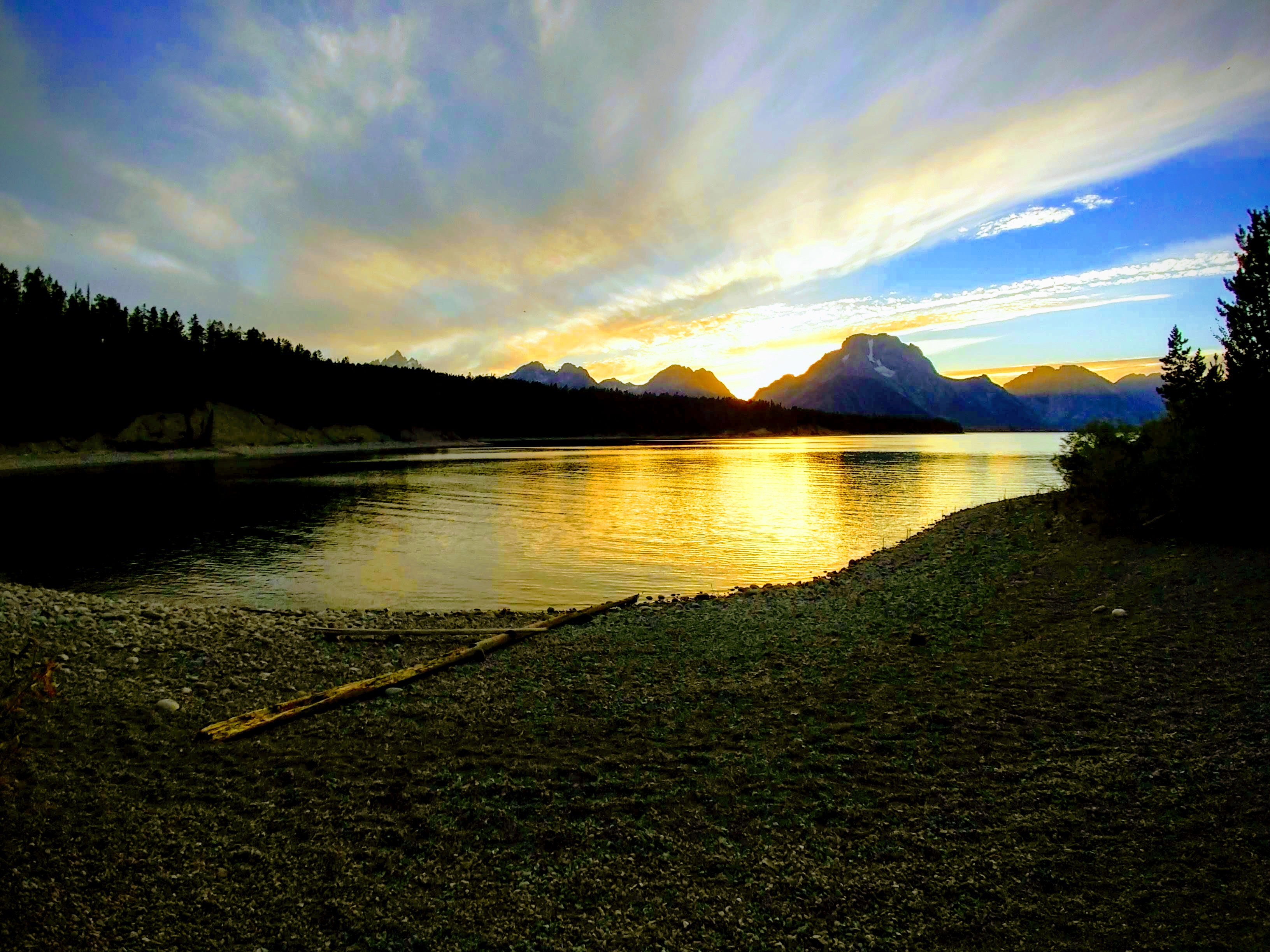
After setting up my sleeping area, it was time to eat some dinner and drink a beer on the shore of the beach. This was perfect timing as the sun was beginning the setting process for the day so I had a spectacular show as I enjoyed both ramen noodle and Blue Moon beer.

Night Time
During the night, I was able to wake up and catch amazing views of the night sky, untainted by light pollution. The Milky Way was readily apparent as it stretched across a portion of my field of view of the sky. There are so many stars. Barely an area of the sky that is completely void of any star illumination. If you stare at stars, you can even see that what appears to be one star becomes a multiple stars in a tight cluster. Your eyes needs to adjust (try focusing on the areas around a star rather than directly at a star). A lot of times the closeness of one overpowers the luminosity of those close in geometric alignment from our location.
This is when sleeping in a bivvy bag under the night sky has its perks, besides being significantly lighter than lugging around a tent of any size. I woke up several times throughout the night and just gazed up from the comforts of my warm sleeping bag. Well worth it despite my face being cold most of the night.
You could also hear several animals and birds making their noise. Luckily the cold and slight breeze kept the bugs and mosquitoes at bay the whole night. Sometime during the night a squirrel or chipmunk ran into me, which woke me up, and begin crawling up the side of my bag. After vigorous movements the rodent ran off and didn’t come back. That certainly weird but humorous!
Daily Stats
Total Miles: 6.84 miles
Total Elevation Gain: 1,223ft
Total Calories Burned (Signal Mountain Hike only): 1775 calories
Total Time (Signal Mountain Hike only): 4hr 33 min

